Casa Rinconada, NM • Hike
 This is likely a great time to hike this trail!  Check out "Preferred" months below, keep in mind this is an estimate.
  

Casa Rinconada, NM

Guide 9 Triplogs Mine 0 2 Topics
 
3.8 of 5 
Fav
Wish
0
details
drive
permit
forecast
map
stats
photos
triplogs
topics
location
24 9 2
HAZ reminds you to respect the ruins. Please read the Archaeological Resources Protection Act of 1979 & Ruins Etiquette
Statistics
tap icons for details
Difficulty 1 of 5
Route Finding 1 of 5
Distance Lasso-Loop 0.75 miles
Trailhead Elevation 6,138 feet
Elevation Gain 50 feet
Avg Time Round Trip 0.5 hours
Kokopelli Seeds 1
 Interest Ruins
 Backpack No
 Dogs not allowed
feature photo
Photos Viewed All MineFollowing
138  2012-06-28
Chaco Culture National Historical Park Trails
Stoic
7  2011-06-21 squatpuke
12  2011-06-19
Kin Bineola
Trishness
8  2010-06-21 PaleoRob
60  2010-06-18
Chaco Culture National Historical Park Trails
Randal_Schulhaus
9  2008-06-22 PaleoRob
Author
author avatar Guides 172
Routes 229
Photos 6,096
Trips 1,129 map ( 2,527 miles )
Age 41 Male Gender
Location Pocatello, ID
Associated Areas
list map done
Northwest Region
Historical Weather
Trailhead Forecast
Expand Map
Preferred Apr, Oct, Mar, May
Seasons   Autumn to Spring
Sun  6:24am - 6:18pm
Route
 
0 Alternative
 
 Water
Nearby Area Water
[ View More! ]
Fauna  Nearby
Culture  Nearby
The sun will come up tomorrow...
by PaleoRob

 Likely In-Season!
Chaco Canyon is full of remarkable features, most notably its Great Houses which dot the northern edge of the canyon and the high points on its rims. While the great houses are certainly impressive, they do not make up the majority of sites in Chaco Canyon. Literally hundreds of small ruins dot the canyon, primarily along the southern walls. Some of these ruins date from Basketmaker times. Many others, however, are of the same age as the Great Houses. These small, generally crudely constructed dwellings differ greatly from their Great House companions in size, masonry style, and layout. The trail at Casa Rinconada explores one of these typical "Hosta Butte Phase" communities, along with one glaring anomaly in their midst.
The trail begins at the signed pull-out along the Chaco loop road, just past the Chaco Wash bridge. There is a pit toilet but no water - make sure your water bottles are filled back at the visitor's center. Also be sure to get a trail guide from the kiosk at the parking area; it will help explain some of the sights in detail. It costs 50 cents, or free if you return it after your hike.

The trail leaves the parking area and slowly begins to rise up a low hill to the southwest, where a large masonry structure can be seen. As you climb this hill, you will be walking over and around a couple of the Hosta Butte Phase sites. Low wall alignments can be discerned sticking out of the greasewood and scrub brush. These sites are interesting in that they show generally what these small sites look like prior to excavation, but a better idea of what these habitations looked like is available further down the trail. For the time being, continue on up towards the masonry structure at the top of the hill.

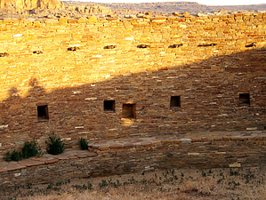
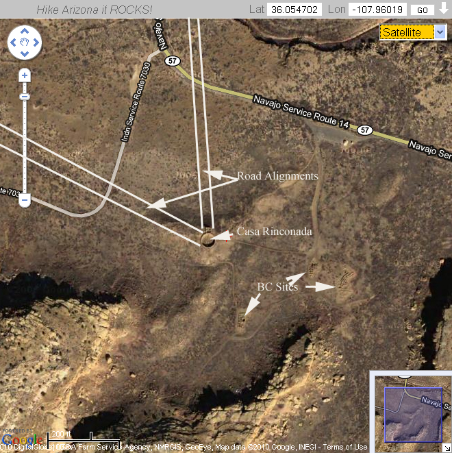
The structure is the Great Kiva of Casa Rinconada. Aligned almost perfectly with the four cardinal directions, it sits directly due south of Pueblo Bonito's dividing wall, through an alignment with its central wall, the gap in the trash mounds in front of Bonito, and Casa Rinconada's northern antechamber. During the summer solstice a beam of light will enter the window to the east of the northern antechamber, and as the sun rises that beam of light will come to rest in a low niche on the western side of the kiva wall; both the window and the niche have been reconstructed in the past, so it is not known how accurate this solar alignment is, but it is striking regardless.

The floorplan of the Great Kiva is fairly standard, with one exception; a tunnel that leads from the northern antechamber to the center of the kiva floor. This may have allowed priests or dancers to appear unseen in the center of the kiva during ceremonies. The tunnel was likely covered with wood and plaster with a reed and wood hatchway at its end.

Casa Rinconada certainly exemplifies the great feats of architecture that the Chacoans could, and routinely did, go to. The next stops along the trail showcase the fact that just because they could build impressive public architecture, they didn't do so all the time.

The next several ruins are some of the BC# small sites. Called Hosta Butte Phase after the prominent butte of the same name to the south of Chaco, where this type was first recognized. These small sites are far more typical of Anasazi dwellings across the Colorado Plateau, with several storage rooms, a couple living rooms, and a kiva or two all within one complex. Usually these consisted of just a single story, though two stories in places were not unusual. These Hosta Butte sites are generally clustered around Great Houses, and likely acted as the support mechanism that allowed the Great Houses to keep doing whatever it was that there were doing. The trail book guides your through some of the pertinent features of several of these sites.

The loop then brings you back to your car. This is the last hike available on the Chaco Loop Road before returning to the Visitor's Center, but don't miss out on the prehistoric staircase just a couple dozen yards down the road. You can't hike to it or climb it, but be sure to stop and look at it just the same. It is a real neat example of Chacoan road engineering.

Check out the Triplogs.

Leave No Trace and +Add a Triplog after your hike to support this local community.

2008-07-01 PaleoRob
  • description related image
    guide related
WARNING! Hiking and outdoor related sports can be dangerous. Be responsible and prepare for the trip. Study the area you are entering and plan accordingly. Dress for the current and unexpected weather changes. Take plenty of water. Never go alone. Make an itinerary with your plan(s), route(s), destination(s) and expected return time. Give your itinerary to trusted family and/or friends.

 Permit $$
NPS

Chaco Canyon HP National Park
$8 per vehicle good for 7 days Entrance Fee


 Directions
or
or
 Road
FR / Jeep Road - Car possible when dry

To hike
From Grants, NM, drive north on NM Route 605 until reaching NM Route 509. Turn left onto NM Route 509. Follow Route 509 north until reaching Navajo Route 9. Turn left onto Navajo Route 9. Proceed on Route 9 until reaching NM Route 57. All of these turns are marked with signs for Chaco Culture National Historic Park.

WARNING! NM Route 57 is a very poor road, with bad washboards, washouts, and chug-holes when it is dry. It is impassable to anything by 4x4 vehicles when wet, and sometimes even not then. Travel at your own risk. Passenger cars can and do make the drive regularly when the weather is good, but be prepared to turn around or get stuck if you attempt to drive to the park in wet weather.

Once Route 57 reaches the park boundary, it becomes paved. Proceed to the visitor center and pay the fee. Follow the loop road past the turn-off for Pueblo del Arroyo. The next parking area (on the right) will be on the south side of the canyon for Casa Rinconada.
page created by PaleoRob on Jun 30 2008 10:24 pm
helpcorrectionissue

end of page marker