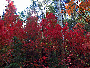
Upper Bear Canyon and West Bear Canyon off-trail hiking can be compared to hiking sections of our Mogollon Rim - Barbershop Canyon and Dane Canyon with significant seasonal water flow and pooling in the Bear Canyon Upper sections as of this June'12 posting. In Autumn, with surprisingly numerous large stands of Big Tooth Maple within the West Bear Canyon section, this LOOP should provide some excellent autumn colors. West Bear Canyon is mostly easy to navigate with only the lower ~1/3 mile section requiring moderate rock/boulder scrambling with creek downfall to negotiate. From its intersection with lower West Bear Canyon, Upper Bear Canyon is nicely shaded in the afternoon with numerous, active animal routes to follow. It is recommended to download and follow the "official" GPS Route posted herein.
For the stronger hiker with off-trail route-finding ability, you can combine this loop hike with the Bear Canyon(Middle) hike guide for a longer 12+ mile "lollypop" loop hike... if planning this option, it is recommended to start/end from the Bear Canyon (Middle) Park/TH Location unless planning a shuttle hike which is also an option.
WARNING! Hiking and outdoor related sports can be dangerous. Be responsible and prepare for the trip. Study the area you are entering and plan accordingly. Dress for the current and unexpected weather changes. Take plenty of water. Never go alone. Make an itinerary with your plan(s), route(s), destination(s) and expected return time. Give your itinerary to trusted family and/or friends.
Permit $$
None
Directions
Road
High Clearance possible when dry
To hike From the Phoenix area- Drive Hwy 87 north through Payson, Pine, and Strawberry.. approx 10.5 miles north of Strawberry on Hwy 87 at MP281.1, turn right at signed FR300 (the Rim Road), and continue on FR300 for ~13.2 miles to the intersection with easy to miss but signed FR398. Turn left onto FR398 and continue for ~0.30 miles to road left side Parking/TH Start for this off-trail hike (at waypoint 34.44440 -111.23384). It is highly recommended that you download and follow the Driving Route (with key waypoints) posted above to this hike description;
page created by Grasshopper on Jun 24 2012 2:26 pm
 Route Editor

 Upper Bear Canyon and West Bear Canyon off-trail hiking can be compared to hiking sections of our Mogollon Rim - Barbershop Canyon and Dane Canyon with significant seasonal water flow and pooling in the Bear Canyon Upper sections as of this June'12 posting. In Autumn, with surprisingly numerous large stands of Big Tooth Maple within the West Bear Canyon section, this LOOP should provide some excellent autumn colors. West Bear Canyon is mostly easy to navigate with only the lower ~1/3 mile section requiring moderate rock/boulder scrambling with creek downfall to negotiate. From its intersection with lower West Bear Canyon, Upper Bear Canyon is nicely shaded in the afternoon with numerous, active animal routes to follow. It is recommended to download and follow the "official" GPS Route posted herein.