Route Editor

| Guide | ♦ | 7 Triplogs | 0 Topics |
details | drive | permit | forecast | route |
stats |
photos | triplogs | topics | location |
| 79 | 7 | 0 |
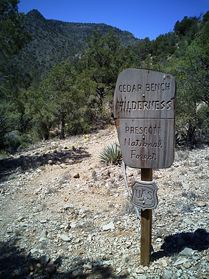
the redheaded stepchild by skatchkins   The Cedar Bench Wilderness has been called the redheaded stepchild of the Arizona Wildernessi. The Prescott National Forest Service purports it to be the least visited in the state. Even so, there are established and named trails in the area, and at the right time of year, you can find yourself amidst large shade trees nurtured by the many area springs and by Chasm Creek. The springs also tell of many types of animal visits by surrounding heavy-use game trails and muddy tracks around the water. The Cedar Bench Wilderness has been called the redheaded stepchild of the Arizona Wildernessi. The Prescott National Forest Service purports it to be the least visited in the state. Even so, there are established and named trails in the area, and at the right time of year, you can find yourself amidst large shade trees nurtured by the many area springs and by Chasm Creek. The springs also tell of many types of animal visits by surrounding heavy-use game trails and muddy tracks around the water.The Goat Camp Spring trail starts out carving a mark through thick scrub brush and then takes you along the edge of Chasm Creek. The contouring path does leave you exposed with not much shade for warmer weather hiking. Its little use means you'll find less visible maintenance but wearing shorts only fetched a negligible amount of scratches. You'll find a couple of seeps from the hillside muddy the path in spots. A sign marks the split for Goat Camp Springs #542 and Hell Hole #541, but it was ill-advised in its creation as its arrows both point straight ahead. Someone has since carved a more helpful arrow denoting Goat's true direction from the split to the left and even penciled in the approximate yards until the creek crossing. The correct trail is pretty obvious, and the trail straight to Hell appears to be dwindling as the brambles take it back, trying to make it more appropriate in name.
After the halfway mark at the Chasm cross, there is some elevation gain-back as you follow the creek upstream and above; Shade here and there keeps it interesting. The best view resides in the small plot of the destination as the growth overhead takes over and darkens out the ground cover. Game trails pop up everywhere, and all feeling of being alone in the woods vanishes. This is a good place to stop and lunch, to wait and watch. Even in the summer, the spring keeps a couple of indentations wet for the animals with the creek dry. Turning your feet around, the hike out goes quickly. There are other trails around that could connect, but I'd avoid hiking the creek directly for too long as the rocky going is substantially slower. In short, the 542 isn't a great trail, and there are far better areas to be found (you're also not going to get a car back there on the 9602J), but it is a solid area that in the right season could keep one occupied and feeling like they may be the first to add their footprints into the path in a long while. Check out the Official Route and Triplogs. Leave No Trace and +Add a Triplog after your hike to support this local community. | |||||||||||||||||||||||||||||||||||||||||||||||||||||||||||||||||||||||||||||||||||||||||||||||||||