username
X
password
register
for free!
help


Hell Hole Trail #541, AZ

Guide 1 Triplog  0 Topics
  3 of 5 
Fav
Wish
3
details
drive
permit
forecast
route  
stats
photos
triplog
topics
location
8 1 0
Statistics
tap icons for details
Difficulty 1.5 of 5
Route Finding 2 of 5
Distance One Way 1.1 miles
Trailhead Elevation 4,266 feet
Elevation Gain 465 feet
Accumulated Gain 539 feet
Avg Time One Way 1 hour
Kokopelli Seeds 2.9
 Interest Seasonal Waterfall & Seasonal Creek
 Backpack Possible - Not Popular
feature photo
Photos Viewed All MineFollowing
Inaugural Calculation on Button Tap!
8  2021-12-12 GrangerGuy
7  2021-12-12
Goat Springs Trail #542
GrangerGuy
Author
author avatar Guides 26
Routes 99
Photos 675
Trips 76 map ( 874 miles )
Age 66 Male Gender
Location Phoenix, AZ
Associated Areas
list map done
Camp Verde Region
Historical Weather
Trailhead Forecast
Radar Map
Expand Map
Preferred Oct, Nov, Mar, Apr → 8 AM
Seasons   Autumn to Spring
Sun  5:19am - 7:29pm
Official Route
 
1 Alternative
 
 Water


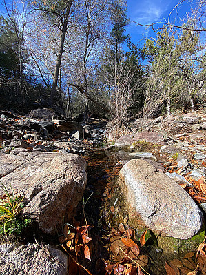
Hard to know why it is called that!
by GrangerGuy

 
Overview
If you are looking for a lonely, easy wilderness trail, Hell Hole Trail should be on your shortlist. Within the Cedar Bench Wilderness of Prescott National Forest, this trail is not well known, in a lightly visited wilderness, and not that easy to get to. But once you find it, it is a beautiful trail, in an as-yet unburned forest, along a pretty little stream.


Hike
The Hell Hole Trail starts about a mile up the Goat Spring Trail at a signed junction. Although the sign at the junction points straight ahead for the Hell Hole Trail, the faint trail heads up the hill to the right. Within about 20 yards, the trail becomes clear and traverses along the hillside parallel to the creek.

The trail is on the north side of the creek, the opposite side of the creek from where the USGS map shows it. While occasionally faint, the trail is easy to follow. There is surprisingly little overgrowth on the trail, for such a little-used trail. The trail climbs up over a bluff and then drops back down to the creek at a great little lunch spot by a cute little waterfall.


Just beyond, the trail goes through a broken-down gate in an old fence, pushes through some catclaw, crosses the ravine, and peters out on the ridge between two creeks.

Check out the Official Route and Triplog.

Gate Policy: If a gate is closed upon arrival, leave it closed after you go through. If it is open, leave it open. Leaving a closed gate open may put cattle in danger. Closing an open gate may cut them off from water. Please be respectful, leave gates as found.

Leave No Trace and +Add a Triplog after your hike to support this local community.

2021-12-29 GrangerGuy

    One-Way Notice
    This hike is listed as One-Way.

    When hiking several trails on a single "hike", log it with a generic name that describes the hike. Then link the trails traveled, check out the example.
    WARNING! Hiking and outdoor related sports can be dangerous. Be responsible and prepare for the trip. Study the area you are entering and plan accordingly. Dress for the current and unexpected weather changes. Take plenty of water. Never go alone. Make an itinerary with your plan(s), route(s), destination(s) and expected return time. Give your itinerary to trusted family and/or friends.

     Permit $$
    None

    Prescott Forest
    Prescott National Forest Pass

    Only trailheads with six "amenities" have fees. Amenities are picnic tables, trash, toilet, parking, interpretive signing and security.


     Directions
    or
    or
     Road
    High Clearance possible when dry

    To hike
    The directions to this trail are the same as to Goat Spring Trail, copied below. While I would say high clearance is possible when dry, I would highly recommend 4x4.

    Steer onto the 1-17 from wherever you're at, exiting on to the 260 in Camp Verde heading East. At 1.7 miles, take Oasis, where you'll be dumped out on Salt Mine Road. Stay on for 6.7 miles. Beware that at a stop sign, Salt Mine Road becomes dirt going straight, and the paved road turns left. Stay on Salt Mine Road and turn right on to FR 9602J. After 2.2 miles of rough dirt, you'll see enough room to park 3 vehicles on the left. You're at the trailhead, and it's shoe time.
    page created by joebartels on Dec 29 2021 6:47 pm
     90+° 8am - 6pm kills
    prehydrate & stay hydrated
    helpcorrectionissue

    end of page marker