Route Editor

| Guide | ♦ | 17 Triplogs | 0 Topics |
details | drive | no permit | forecast | 🔥 route |
stats |
photos | triplogs | topics | location |
| 150 | 17 | 0 |
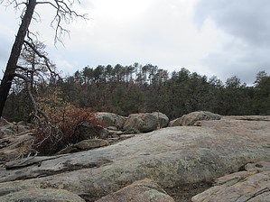
Taller than a Pine Tree by DixieFlyer  Warning WarningThe Bush Fire heavily impacted this area in 2020. Be careful during periods of heavy rain, as flash flooding could occur. Overview Pine Mountain (elevation of 6,236' and prominence of 426') is in the Mazatzal Mountains, about 6 miles northwest of the Four Peaks. It is one of at least five peaks in Arizona with the name "Pine Mountain"; it is sometimes referred to as the Camp Benchmark. It is the 14th highest peak in Maricopa County.
This guide describes the route to Pine Mountain from the Cline Trailhead. There are other possible ways to get to Pine Mountain, but the most straightforward way is from the Cline Trailhead. From the trailhead, the hike goes on the Ballantine Trail for about 2.75 miles. Then it goes off-trail up to the Pine Mountain summit. The first 1.5 miles on the Ballantine Trail was heavily burned by the Bush Fire in 2020. The fire was of very high intensity in this area, and at the time this guide was written, there is very little vegetation left. That will change in the coming months and years as the vegetation regrows, but for now, there are no issues with the trail being overgrown, as was the case before the fire. The trail is generally easy to follow in this section -- there are several cairns along the way. Nonetheless, many hikers will find a GPS track helpful. After about 1.5 miles, the trail was not impacted by the Bush Fire and became brushy and overgrown. Shortly after leaving the burn area, a section of the trail is challenging to follow, and the trail essentially does not exist for a short distance. However, if you persevere, you can get back on the trail, which becomes reasonably easy to follow. There are cairns along the way, which are helpful. Plan on brushing up against some vegetation in many places, as the trail has not been maintained in quite some time. At about 2.75 miles into the hike, you'll be at about 5,900' in elevation, and you'll go off-trail to the southwest to make your way to the summit. A good place to leave the trail is somewhere near these coordinates: 33.75192, -111.39367 Once you get off-trail, you'll once again be in a burned area from the fire, so there is very little brushy vegetation to deal with. The grade on the ascent is not particularly steep, and with most of the vegetation gone, it is a relatively easy off-trail ascent. The fire did not make it up to the summit, so there is a bit of vegetation to deal with just before reaching the summit. The summit is somewhat flattish, and with some trees around, the views are a bit obstructed. Nonetheless, if you walk around a bit, you can enjoy some nice scenery. Return to the trailhead the same way that you came. Synopsis This hike will not likely make someone's top ten list; however, it is a nice area to explore if you don't mind some off-trail hiking and hiking on somewhat overgrown trail places. Check out the Official Route and Triplogs. Leave No Trace and +Add a Triplog after your hike to support this local community. | ||||||||||||||||||||||||||||||||||||||||||||||||||||||||||||||||||||||||||||||||||||||||||||||||||||||||||||||||||||||||||||||||||||||||||||||||||||||||||||||||||||||||||||||||||||||||||||||||||||||||||||