 Route Editor

| Guide | ♦ | 33 Triplogs | 0 Topics |
details | drive | permit | forecast | route |
stats |
photos | triplogs | topics | location |
| 203 | 33 | 0 |
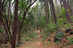
history and mystery in the oak jungle by PrestonSands   Overview OverviewConveniently located along Highway 89A between the Mingus Summit and Jerome, The Mescal Trail #547 ascends the shady, forested confines of Mescal Gulch, between Forest Road 338 and the Bug Hollow Trail #548. It can be hiked by itself or in conjunction with its connecting trails: Upper Mescal Trail #550, Bug Hollow Trail #548, and North Mingus Trail #105. History The bottom half of the Mescal Trail roughly follows the route of the original wagon road to Jerome (see the "Jerome-Prescott Wagon Road" hike for more on that). One can see evidence of Mescal Gulch's historical use in the form of old rock walls and an abandoned rock watering trough below a now-dry spring.
The Mescal Trail begins below the highway embankment, near the start of Forest Road 338, and is marked by a fiberglass signpost with "547" on it. The Mescal Trail begins following a closed road up a grassy flat, paralleling Highway 89A. A brief and unexpected jog to the right near the beginning of the trail is marked by a few cairns. This is the only potentially confusing spot on the hike. As one hikes up the western bank of Mescal Gulch on the old roadbed, large Gambel oaks and ponderosa pines close in on the Mescal Trail, creating a pleasant, shady environment. Elevation gain is minimal. High above and out of sight on the mountain slope to your right is Highway 89A. About a half-mile in, the trail passes what appears to have been a long-abandoned rock watering trough below an old (and now dry) spring. Beyond this point, the old roadbed that the trail has been following becomes overgrown and eventually vanishes. The trail continues, however, as a well-cairned path. The gradient of Mescal Gulch increases and the Mescal Trail climbs steadily through big trees, weaving around rocks and repeatedly crossing the rocky creek bed. Though the trail appears to see little use, cairns are plentiful. After a nice little climb, the Mescal Trail comes to an end where it meets the Bug Hollow Trail #548 at a signed junction amid tall ponderosa pines. A nice return hike option is to hang a left on the Bug Hollow Trail and follow it back to the beginning of the Mescal Trail. See the Bug Hollow Trail #548 hike for more information on this option. Check out the Official Route and Triplogs. Leave No Trace and +Add a Triplog after your hike to support this local community. One-Way Notice This hike is listed as One-Way. When hiking several trails on a single "hike", log it with a generic name that describes the hike. Then link the trails traveled, check out the example. | |||||||||||||||||||||||||||||||||||||||||||||||||||||||||||||||||||||||||||||||||||||||||||||||||||||||||||||||||||||||||||||||||||||||||||||||||||||||||||||||||||||||||||||||||||||||||||||||||||


