 Route Editor

| Guide | ♦ | 1 Triplog | 1 Topic |
details | drive | permit | forecast | 🔥 route |
stats |
photos | triplog | topic | location |
| 30 | 1 | 1 |
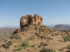
Short, steep, great Picketpost view! by CannondaleKid   Peak 4140 is located in the Mineral Mountain Quadrangle, which is just south of the US 60 between Florence Junction and Superior. Typical of peaks in the Mineral Mountain Quad, the drive to the trailhead is every bit as much of a challenge as the actual climb, and Peak 4140 is no different. Depending on the capability of your vehicle and how far you are willing to drive it, one-way this hike can be less than half-a-mile or up to 2 miles each way. If you begin your hike from the same point as I did, it will be the same trailhead as for used for Peaks 4141 & 4020. Peak 4140 is located in the Mineral Mountain Quadrangle, which is just south of the US 60 between Florence Junction and Superior. Typical of peaks in the Mineral Mountain Quad, the drive to the trailhead is every bit as much of a challenge as the actual climb, and Peak 4140 is no different. Depending on the capability of your vehicle and how far you are willing to drive it, one-way this hike can be less than half-a-mile or up to 2 miles each way. If you begin your hike from the same point as I did, it will be the same trailhead as for used for Peaks 4141 & 4020.From the trailhead you start right away with a steep climb, gaining 250' in the first 0.2 miles. At that point, it levels out and you start to descend to a saddle before an easy ascent toward the base of Peak 4140. As you approach the peak itself it may appear a bit daunting if you're not a climber, but if you bear to your right around the base you will find any easy route up the chute to the summit. The views from the summit are well worth the rough drive and short hike. To the northeast, the prominence of Picketpost Mountain is the most noticeable feature.
Check out the Official Route and Triplog. Leave No Trace and +Add a Triplog after your hike to support this local community. One-Way Notice This hike is listed as One-Way. When hiking several trails on a single "hike", log it with a generic name that describes the hike. Then link the trails traveled, check out the example. | ||||||||||||||||||||||||||||||||||||||||||||||||||||||||||||||||||||||||||||||||||||||||||||||||||


