Route Editor

| Guide | ♦ | 1 Triplog | 1 Topic |
details | drive | permit | forecast | 🔥 route |
stats |
photos | triplog | topic | location |
| 25 | 1 | 1 |
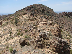
awesome summit views by CannondaleKid   Peak 4020 is located in the Mineral Mountain Quadrangle, which is just south of the US 60 between Florence Junction and Superior. Typical of peaks in the Mineral Mountain Quad, the drive to the trailhead is every bit as much of a challenge as the actual climb, and Peak 4020 is no different. Depending on the capability of your vehicle and how far you are willing to drive it, one-way this hike can be as short as 1.4 miles or just over 3 miles each way. If you begin your hike from the same point as I did, it will be the same trailhead as used for Peaks 4140 & 4141. Peak 4020 is located in the Mineral Mountain Quadrangle, which is just south of the US 60 between Florence Junction and Superior. Typical of peaks in the Mineral Mountain Quad, the drive to the trailhead is every bit as much of a challenge as the actual climb, and Peak 4020 is no different. Depending on the capability of your vehicle and how far you are willing to drive it, one-way this hike can be as short as 1.4 miles or just over 3 miles each way. If you begin your hike from the same point as I did, it will be the same trailhead as used for Peaks 4140 & 4141.From the same trailhead, rather than the immediate climb for Peak 4020, you will slowly descend along the same ancient Jeep trail as you would for Peak 4141 but in this case, you will continue until it rises to a flat natural tank area. Since there is no trail as such, when and where you decide to climb is up to you. The first peak above on your right is NOT Peak 4020, but I'd still recommend ascending toward it. Once you near the top, bear left and follow the saddle to the south. Now with a good view of Peak 4020, you can adjust your route as you go. As you approach Peak 4020, just stay slightly to the right of the rocky ridge and you should have no problem reaching the summit, which is a large flat area.
Being so close to Peak 4140 and Peak 4141, you may want to climb them as well for a three-peak day. Check out the Official Route and Triplog. Leave No Trace and +Add a Triplog after your hike to support this local community. | |||||||||||||||||||||||||||||||||||||||||||||||||||||||||||||||||||||||||||||||||||||||||||||||||||||