Overview
Peak 3937 is located in the Mineral Mountain Quadrangle, which is just south of the US 60 between Florence Junction and Superior. Typical of peaks in the Mineral Mountain Quad, the drive to the trailhead is every bit as much of a challenge as the actual climb, and Ajax Benchmark is no different. Depending on the capability of your vehicle and how far you are willing to drive it, this hike can be as short as 2.5 miles to more than 10 miles round-trip.
Hike
From the parking area near the Arizona Trail #17 TH, begin the hike heading north along the FR976 about 500' until you meet the AZT#17, then turn left onto AZT#17 and follow it .2 mile where you will turn right onto an old jeep trail. The trail will descend to the bottom of the drainage before climbing steeply up the other side. At some points, you may be climbing up the ancient 'road' on all fours to keep from sliding back down. (Just think of trying to drive up here... some ATVs have not too long ago. I know my Samurai could if it HAD to, but I would only attempt it if it was an emergency.)
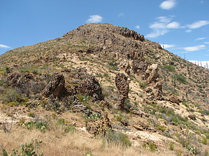
Once you reach the saddle, there is no specific trail to the summit of Peak 3937 so just head up the slope to your left. The climb is not very steep here and the vegetation is spread out enough that you can pretty much choose whatever route you wish. At the summit, you will find a small rock cairn with a summit log. If all you wanted to do was bag the summit, you can head back for a hike of barely 1.5 miles, but now that you are here, don't pass up the best views, which you will experience only if you walk along the ridge as far as you can to the south. The views I encountered are some of the best I've experienced in the whole Mineral Mountain Quadrangle. Well worth the long rough drive! To the east, you can see a good chunk of AZT#16 as it traverses across the slopes. To the west, you have a good view of the Martinez Mine area including the huge cave and the oasis of trees by the old houses. Since there isn't any other way to return to the trailhead without a long detour and/or using very good climbing skills, return roughly along the same route.
WARNING! Hiking and outdoor related sports can be dangerous. Be responsible and prepare for the trip. Study the area you are entering and plan accordingly. Dress for the current and unexpected weather changes. Take plenty of water. Never go alone. Make an itinerary with your plan(s), route(s), destination(s) and expected return time. Give your itinerary to trusted family and/or friends.
Permit $$
AZ State Recreational Land Permits
For hiking, driving & sightseeing purposes, you seek a recreational permit.
Under "Recreational Land Use" in the link above.
2022 - $15.00 individual
2022 - $20.00 family limited to two adults and children under the age of 18
Plus $1 processing fee
The permitting process is quick, you will be emailed your permit instantly.
To hike Take the US 60 east toward Globe, continuing about 3.5 miles east of Florence Junction to the turn-off onto the dirt North Mineral Mountain Road. You will be crossing Arizona Trust Land so be sure to have secured your annual permit. Heading south from the US 60 you will continue on N Mineral Mtn Rd to the junction with Ajax Mine Trail (road) at about 7 miles. (Note, there will be other junctions before this point so I'd recommend you download the GPS route for the drive.) Continue east on Ajax Mine Trail for about 5.2 miles to N33.20716 W111.15008. This is the junction where Ajax Mine Trail, Telegraph Canyon Road (SW from Superior), and Forest Road 976 meet at N33.20699 W111.15022. Follow FR 976 3.2 miles to the trailhead, which is within .1 mile of the AZT #17 TH (The end of #16 and the start of #17). I'd suggest following the GPS route I posted of the drive from the US60 to the TH.
[ALTERNATE Eastern Approach] NOTE: I recommend this approach ONLY if you are coming from Superior or points east because you will save 5.5 miles off-road. However, from the west, you'll add 11 miles on the US60 and thus add 5+ miles to the total drive, plus the last 4 miles to FR 976 on Telegraph Canyon Road is MUCH rougher! To follow this approach, turn south on Mary Street from the US60 (west end of Superior) at N33.28540 W111.11757. Follow Mary St to Golf Course Rd, turning right immediately after the Fire Station. About two miles out (shortly after it becomes a dirt road) turn right onto Forest Road 4, which is Telegraph Canyon road. Follow FR4 to FR976 at N33.20699 W111.15022. Follow FR 976 3.2 miles to the trailhead.
page created by CannondaleKid on Jul 10 2012 8:48 am
 Route Editor


 Overview