username
X
password
register
for free!
help
  

Bajada Wash, AZ

Guide 4 Triplogs  0 Topics
  2 of 5  
Fav
Wish
0
details
drive
permit
forecast
route  
stats
photos
triplogs
topics
location
0 4 0
Statistics
tap row or icons for details
Difficulty 1.5 of 5
Route Finding 1 of 5
Distance Multi-Loop 1 mile
Trailhead Elevation 2,709 feet
Elevation Gain 136 feet
Accumulated Gain 136 feet
Avg Time One Way 30 minutes
Kokopelli Seeds 1.45
 Backpack No
 Dogs not allowed
feature photo
Photos Viewed All MineFollowing
14  2022-08-14
SNP Wild Horse Tanks
markthurman53
10  2017-07-18
Shantz Squeeze Pen Bajada Wash
markthurman53
Author
author avatar Guides 34
Routes 249
Photos 2,197
Trips 592 map ( 4,584 miles )
Age 38 Male Gender
Location Portland, OR
Associated Areas
list map done
Tucson Region
Historical Weather
Trailhead Forecast
Radar Map
Expand Map
Preferred Feb, Jan, Dec, Mar
Seasons   Early Autumn to Early Summer
Sun  6:00am - 6:43pm
Official Route
 
2 Alternative


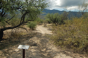
Blissful Bajada
by keepmoving

Bajada - definition and pronunciation


Overview
As the name suggests, Bajada Wash is a short hike through a desert wash in Saguaro National Park East. The hike begins at Shantz Trail and runs to Garwood Trail, passing Creosote and Wildhorse Trails along the way.
remove free decal offer
Hike
From Shantz Trail, turn at the trail marker and follow the wash as it heads southeast. This section of the hike is more akin to following a well-worn path than actually walking in a wash. The trail here is a deep grove in the sand that passes through a relatively wide plain punctuated by trees.

At 0.2 miles, you will encounter a marked junction with the Creosote Trail. You will continue straight ahead along the same path you were following, and the wash will gradually begin to widen.

At 0.4 miles, you will reach another signed junction with the Wildhorse Trail. Up to this point, you have been following the northern section of the Bajada Wash. You will now have to turn right and follow Wildhorse Trail for 0.1 miles until you reach a signed junction on the left that marks the continuation of Bajada Wash South.

Past Wildhorse Trail, Bajada Wash will begin to follow a much curvier path through the desert landscape. As you work your way through this section, the trail will gradually transition from sand to rocks as it climbs its way up to Garwood Trail junction.

Warning
During monsoon season, flash floods can pose serious hazards, and it is advisable to stay out of washes.

2012-07-14 keepmoving
  • Rincon HAZ Map
    area related
    Rincon HAZ Map
  • Rincon Mountain Distric East
    area related
    Rincon Mountain Distric East
  • Tucson Mountain District West
    area related
    Tucson Mountain District West
  • SNP Cactus Forest Map
    area related
    SNP Cactus Forest Map
  • nps related
  • sub-region related


Check out the Official Route and Triplogs.
Leave No Trace and +Add a Triplog after your hike to support this local community.

One-Way Notice
This hike is listed as One-Way.

When hiking several trails on a single "hike", log it with a generic name that describes the hike. Then link the trails traveled, check out the example.
WARNING! Hiking and outdoor related sports can be dangerous. Be responsible and prepare for the trip. Study the area you are entering and plan accordingly. Dress for the current and unexpected weather changes. Take plenty of water. Never go alone. Make an itinerary with your plan(s), route(s), destination(s) and expected return time. Give your itinerary to trusted family and/or friends.

 Permit $$
NPS

Saguaro National Park
2022 $25 vehicle • $20 motorcycle • $15 individual on foot or bicycle
Receipt is valid for 7 days
$45 Annual Park Pass View All

No fee required from Miller Creek Trailhead off Mescal Rd.


 Directions
or
 Road
Connector trail - Not Applicable

To Douglas Spring Trailhead
From I-10 & Speedway Blvd exit #257, travel East on Speedway Blvd 17.4 miles to the trailhead.

The final major crossroad will be Freeman and "Dead End" signs will begin to appear. The trailhead is a small parking area with a picnic table and ample signage at the dead end of Speedway.

From PHX (I-10 & AZ-51) 129 mi - about 2 hours 17 mins
From TUC (Jct 1-10 & Grant) 19.4 mi - about 41 mins
From FLG (Jct I-17 & I-40) 272 mi - about 4 hours 23 mins
page created by keepmoving on Jul 13 2012 10:29 pm
 90+° 8am - 6pm kills
helpcorrectionissue

end of page marker