 Route Editor

| Guide | ♦ | 1 Triplog | 1 Topic |
details | drive | no permit | forecast | 🔥 route |
stats |
photos | triplog | topic | location |
| 9 | 1 | 1 |
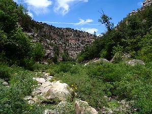
Locust Bush HQ by nonot  Overview OverviewWillow Creek from approximately 1 mile below Pius Farm Draw to East Clear Creek Warning Water will be a problem in summer and fall, possibly in spring if the winter was dry.
Scramble down from the rim into the creekbed. Don't jump off cliffs, but otherwise, there is no wrong way to do it. The first few miles heading downstream are pretty easy - the elk trails are fantastic and stay on the sandy berms, occasionally crossing. After a few miles, the locust bush gets thicker, and the elk trails get worse. I observed several elk trails depart for the rim. The creek is bone dry in summer. Stick to the sides of the creek and avoid the locust gauntlet in the creek bed as best you can. Overgrown elk trails can be found on one side or the other for the most part. The poor trail conditions persist, but as you approach the East Fork of Willow, the creek walls begin to weave back and forth. The high walls of the canyon consist primarily of broken-down Coconino. The overgrowth is unrelenting, and your will to continue may be weakened, but push on after realizing few visit this area and the lack of human evidence is why you are here in the first place! There are some good elk trails as you approach Cabin Draw, and the forest is thicker there, and the best elk trails are on the opposite side, so I didn't observe precisely where the draw came in. I was hoping to see a cabin, but I was behind schedule and didn't stop to investigate. After Cabin Draw, there are a few more sharp bends in the canyon, and then it straightens out, with about 2 miles of locust bush to go using some sparse elk paths that are almost nonexistent. Approaching East Clear Creek, I finally got on a suitable bench on the left, found an old moonshiner camp, and headed for the cool waters. Reaching ECC, I found it was bone dry, a victim of the water diversion efforts. What a tragedy! Of concern to the hiker - replenishing your water supply will be urgently on your mind. Be aware; there is none within 1.3 miles upstream in ECC. Highlights of the trip will be sighting elk. I observed quite a number of these incredible beasts and found about a dozen shed antlers. Water Sources A few nasty pools were observed in Willow Creek, but water is quite a concern here in summer. East Clear Creek is sometimes bone dry due to the diversion system so that more people can water their lawns. Absolutely atrocious, before they diverted the water, this area was a paradise! Carry way more than you think you need. A poor source is better than none at all. Consider going after a good rain; you may find a few tinajas and get a quart or two at a time. Camping Camping throughout the creek on high banks. No established sites were found; please avoid making a mess and protect this pristine environment. Leave no trace besides your footprints. Check out the Official Route and Triplog. Leave No Trace and +Add a Triplog after your hike to support this local community. One-Way Notice This hike is listed as One-Way. When hiking several trails on a single "hike", log it with a generic name that describes the hike. Then link the trails traveled, check out the example. | |||||||||||||||||||||||||||||||||||||||||||||||||||||||||||||||||||||||||||||||||||||||||||||||||||||||


