Route Editor

| Guide | ♦ | 14 Triplogs | 1 Topic |
details | drive | permit | forecast | map |
stats |
photos | triplogs | topic | location |
| 287 | 14 | 1 |
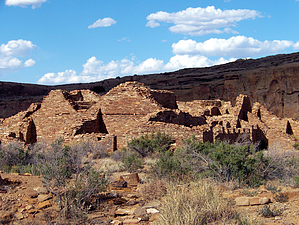
Explore Downtown Chaco by PaleoRob  The hike begins at the Pueblo Bonito/Chetro Ketl parking area. There is a bathroom here, but no water, so make sure you've filled up your water bottle before leaving the Visitor's Center. Head north on the trail, away from Pueblo Bonito. The trail bends to the east shortly after leaving the parking area. Before the trail bends, however, there is a stand with trail guides. Pick one up; it will greatly improve your understanding of the massive ruin you're about to explore.
The trail drops down into the plaza, and you start to get a sense of the size of Chetro Ketl. The plaza was built 12 feet above the surrounding desert floor on purpose, though what that purpose was we don't known. Likely it had something to do with increasing the awe-inspiring power of the building. The trail heads north towards a well-preserved section of rooms against the north wall. There are a couple of interesting things in this section, including a preserved section of excavation that shows the depth of fill that the walls were built on, as well as how much of the walls you're looking at are still underground. There are also some filled-in doors, an always-interesting phenomenon. The neatest part of this area, though, is behind a locked plexiglass door; a room with its original plaster and painted designs, consisting of a pseudo-checkerboard design in green and blue. The plexiglass is usually dirty with some scratches, but a quick rub of the sleeve should clean it up well enough to make out the designs. Once you've taken in your fill of this awesome sight, return back to the plaza by way of your original trail. The trail takes off to the east again, paralleling the southern wall of this roomblock. You can see, if you look at the wall on the left, evidence of multiple walled-in doors or windows. These formed a colonnade before they were walled in, the only one known in the southwest. Some archaeologists take this as evidence for connections between Mesoamerica and the Anasazi world, while others dispute this. None the less it is an interesting feature, no matter what it means. The trail follows the south wall of the room block for a bit more, then turns south and circles the excavated Great Kiva in the plaza. Several Great Kivas were constructed here, one over the foundations of the previous one, with the original kiva floor laying 12 feet below the most recent kiva floor. The kiva shows off most of the common and interesting features found in Great Kiva construction, including round disks used as foundation stones for the big roof support beams. The trail then ventures over the the southern plaza-enclosing wall, which contained an enclosed passageway allowing someone to walk from the southwest to southeast corner of the building. The trail then heads north, along the eastern section of rooms. There are some small kivas here, including one odd "double" kiva, but the trail guide provides no information about it, and I have none either. Eventually the trail ends up back near the central room block, and if you go down a flight of stairs you can see several overlapping kivas that were built on top of each other, in the same manner as the Great Kiva out in the plaza. Take the stairs back up to and continue along the trail. To your west from a high point on a backfilled room you can see an elevated kiva, which is a kiva built on the second or third floor, but isn't actually two or three stories tall; those multi-story kivas are instead called tower kivas, and Chetro Ketl has none of them. As you continue along the trail you go through a couple doorways and emerge on the north side of Chetro Ketl, next to the incredibly long and straight north wall of the building. The trail follows this wall to its end, then turns north and follows the cliff face to take you through the Talus Unit. Occupied at the same time as Chetro Ketl, it likely functioned as part of the integrated Great House community. Interestingly in one of the rooms of Talus Unit is the base of a ramp that would have served part of the Chacoan road system coming off Chaco Mesa down to Chetro Ketl. From here the trail divides again. To take the Petroglyph Trail, follow the trail paralleling the cliff face. Otherwise head south and meet up with the trail you took into the ruins. Check out the Triplogs. Leave No Trace and +Add a Triplog after your hike to support this local community. | |||||||||||||||||||||||||||||||||||||||||||||||||||||||||||||||||||||||||||||||||||||||||||||||||||||||||||||||||||||||||||||||||||||||||||||||||||||||||||||||||||||||||||||||||