Route Editor

| Guide | ♦ | 5 Triplogs | 0 Topics |
details | drive | permit | forecast | route |
stats |
photos | triplogs | topics | location |
| 7 | 5 | 0 |
Canyons are inherently risky. Flash floods occur without notice on sunny days. Technical skills & surrounding topography knowledge required yet does not eliminate risk.
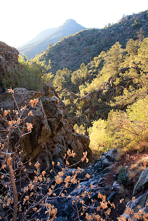
Yeager or Yaeger? Whatever, come play! by PrestonSands  Overview OverviewNot to be confused with Little Yaeger Trail, Little Yaeger Canyon tumbles down the western slope of Mingus Mountain. This short canyon features several small, easily bypassed seasonal waterfalls. Technical climbing gear is not needed. One can incorporate Little Yaeger Canyon into the Yaeger loop or enjoy it by itself. Warning Bring topo maps and or a GPS for this hike. While this is not a problematic canyon, please assess your abilities and don't get in over your head.
From the roadside trailhead at mile 333.25 on U.S. Highway 89A, follow the Little Yaeger Trail #533 (identified by a brown fiberglass post with "533" on it) down to the creek bed in Yaeger Canyon. Cross the creek and travel a short distance up Yaeger Canyon to the first side canyon on your right (east), Little Yaeger Canyon. An old roadbed leads up the south bank of Little Yaeger a short distance, ending at a long-abandoned mine. A cow path takes one a bit further. The canyon is well shaded here, and you might notice stacked rocks along the canyon wall, which once supported a water pipeline. The canyon closes in at its first bend, where you will find a concrete box housing Yaeger Spring beneath tall pines and leafy boxelder trees. There may be water in the box. The going becomes slower beyond the spring, and the canyon turns rocky. Several small seasonal waterfalls, all easily bypassed with a bit of scrambling, are encountered as one ascends the twisting route of Little Yaeger Canyon. After passing the tallest of the seasonal waterfalls just below the 6400-foot contour, the canyon suddenly levels out. Bigtooth maples, oaks, and even a few unexpected aspens fill the canyon bottom, where a cow path offers an accessible route. Another bend in the canyon at 6500 feet brings a short rocky stretch. Bypass it on the north. Beyond this point, Little Yaeger Canyon widens and becomes flatter. Ponderosa pines fill the canyon bottom in this pleasant area, perfect for a break. Little Yaeger Canyon comes to a fork at the 6600-foot contour. Thorny locust brush chokes the right, and the left parallels the Yaeger Cabin Trail #111. The quickest option to exit Little Yaeger Canyon is to make a 200 foot climb up the broad, gentle, open ridge between the two forks to the Yaeger Cabin Trail #111. A left turn on the Yaeger Cabin Trail will take you back to Highway 89A via the Yaeger Canyon Trail #28, while a right will take you back via the Little Yaeger Trail #533. Reversing your route back down Little Yaeger Canyon is the most challenging option. Check out the Official Route and Triplogs. Leave No Trace and +Add a Triplog after your canyon trip to support this local community. | |||||||||||||||||||||||||||||||||||||||||||||||||||||||||||||||||||||||||||||||||||||||||||||