 Route Editor

| Guide | ♦ | 72 Triplogs | 0 Topics |
details | drive | permit | forecast | route |
stats |
photos | triplogs | topics | location |
| 144 | 72 | 0 |
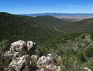
Fast and harsh by Abe   Note NoteThis Guide Reads in reverse to the one-way Official Route. Abe's three-trail loop hike: #1) Little Yaeger Trail #533, 2.1mi#2) Yaeger Cabin Trail #111, 2.0mi #3) Yaeger Canyon Trail #28, 2.0mi Continuing on from Yaeger Cabin Trail #111 Trail #350! Where the heck is Yaeger Canyon Trail #28? I studied the area a little, more aggravated than concerned. One of those rare times I did not bring a map. Nevertheless, I had an idea where I was and the direction I needed to take, so I hooked a left.
Also designated a mountain bike trail, I cannot imagine a mountain biker wanting to take this harsh, rocky, scrub oak choked trail; I can best describe it as fast going down! Heck, a couple of times, I slipped and fell, barely avoiding slamming onto my behind. The view to the west is fine when you catch glimpses of Lonesome Valley and see the ribbon of the black pavement of highway 89A. Looking at the view, I realized, hiking down this trail early afternoon, that the sun was beating down on me. And of the three trails I have hiked, this one is the most exposed; crowded only with bushes, mostly scrub oak. Nonetheless, the trip down was quick, more than likely my doing. Shade trees in the dry creek bottom waited for me. Once at the bottom, you run into a gate, and the trail stops on an old roadbed, a cattle guard to the right. Passing through the gate, I followed the old roadbed where it comes upon an old bridge. I have seen it often as I passed it on my way up to Jerome or Woodchute. I could easily travel to the past through my mind's eye, say to the forties, and see old vehicles full of family members crossing it on their way to cool pines of Mingus. An exciting ride then, I am sure, as it is today. Passing the old bridge, it did not take long to arrive at the trailhead. Movement caught my eyes through the trees, and I walked towards it. It was a biker gent picking up brass shell casings, his bike parked nearby under a tree which afforded it some shade. We chatted a while, he was picking up the brass to sell, and we both marveled at the waste of the shooters, both agreeing gentlemen shooters would have picked up their brass to reload later and save money. Such is not the case here. Bidding farewell, I finished my hike arriving at my old Jeep. Gate Policy: If a gate is closed upon arrival, leave it closed after you go through. If it is open, leave it open. Leaving a closed gate open may put cattle in danger. Closing an open gate may cut them off from water. Please be respectful, leave gates as found. The exception is signage on the gate directing you otherwise. Prescott FS Details Yeager Canyon Trail #28 This trail on the west slope of Mingus Mountain offers fine views of Lonesome Valley, the Prescott Valley area, and the Bradshaw Mountains. The trail starts in ponderosa pine but at lower elevations below the rim stays mostly in pinyon pine and juniper. There is a nice riparian bottom and deciduous hardwoods along the portion of the trail that parallels Highway 89A for about 0.7 miles in Yeager Canyon. This trail is in good condition, having been maintained during 1990. Maps, other resources: Prescott National Forest, east half; U.S.G.S. topographic 7.5' quad for Hickey Mountain. Trail layout: For about 0.5 miles the trail gradually descends to the west. It then turns southwest and descends rapidly through a series of switchbacks into Yeager Canyon. Once in the canyon bottom, it is then only about 0.6 miles to where the trail ends on Highway 89A. Check out the Official Route and Triplogs. Leave No Trace and +Add a Triplog after your hike to support this local community. One-Way Notice This hike is listed as One-Way. When hiking several trails on a single "hike", log it with a generic name that describes the hike. Then link the trails traveled, check out the example. | |||||||||||||||||||||||||||||||||||||||||||||||||||||||||||||||||||||||||||||||||||||||||||||||||||||||||||||||||||||||||||||||||||||||||||||||||||||||||||||||||||||||||||||||||||||||||||||||||||||


