Route Editor

| Guide | ♦ | 9 Triplogs | 0 Topics |
details | drive | permit | forecast | route |
stats |
photos | triplogs | topics | location |
| 34 | 9 | 0 |
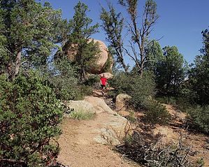
One of Payson's Best by donqcryer   Overview OverviewSedona has its well-known Red Rocks, but few know how beautiful Payson's Pink Rocks can be. Stewart's Pocket area may very well rival Sedona for its scenic beauty. Flanked by Stewart Ridge on the South and the Mogollon Rim on the north it not only contains the amazing boulder formations of Granite Dells but numerous peaks or knolls, many topped by pink rocks. This lasso loop hike on the south side of Stewart Pocket / Granite Dells may be one of Payson's best hikes. Going counter-clockwise on the loop portion, this established single-track trail climbs steeply 1/2 way up Stewart Ridge and then meanders along the grade in and out of the cool forest and rock formations. The views north of the Dells, knolls, and Mogollon Rim are fabulous! After a mile, it lumbers back down past a grotto, a giant house-size rock formation, and a giant balanced rock. Numerous lush seasonal creeks are crossed as well as gnome custom-made wooden wash bridges. This trail is primo for mountain biking. Throw in that the trail can not get muddy, seldom used, and no ATVs or dust, and you gotta luv it! History This single track was beautifully constructed by Payson's forest mountain bike gnomes...
Finding the start of this lasso trail can be confusing, but once on it, the rest of the trail is obvious. There are 2 lassos here (look at GPS map), depending on how you end the loop. I will describe the bigger loop, which has less of a double-back. Beginning at the PATS Cypress TH at the end of E Phoenix Street, go over the ATV trail barrier, and within 50 yards take the 2nd right onto a faint trail. If you come to a wash on the PATS Cypress access trail, you have missed the turn-off. The faint trail soon crosses a wash and at the top of the wash bank, go straight through a 4-way intersection (the trail to the left is the end of the longer loop portion of this trail; to the right, the trail goes by the mountain bike park and then merges with the trail that goes up to the Gibson Court/Phoenix Str PATS Round Valley TH.) In a 100 yards or so, merge left at a Y intersection (the trail coming in from the R is the connector lasso trail from the PATS Round Valley TH at the Gibson Court cul-de-sac off of Phoenix St.) After another 100 yards or so, the trail crosses a small shaded wash and soon (< 100 yards) comes to a flat open area. Look closely for a trail going off to the right. It may be flagged and/or cairned. Go Right; the trail will be obvious for the next 2 miles... [Going R (counter-clockwise loop) is a step going up; going straight goes clockwise and the climb up is more gradual]. There is only one intersection on the loop, and near the loop, end (after 2 miles, see map) and going straight (S) at this intersection (vs R), is a short connector trail for 100 yards back to the initial loop intersection. This intersection may be cairned and/or flagged (if you miss this intersection, no worries, you will soon see that initial loop intersection and you just backtrack to the TH). If you do find the intersection, go R - and looking ahead to get your bearings, you will be heading for the left side of the slickrock knoll that is 100 yards to the west. The trail does cross slickrock on this section, so be observant. After crossing a minor wash, the trail turns S and up and after 50', makes a hard right over slickrock, then heads for the L side of the slickrock knoll. Staying on the left side of the knoll, the trail will make an S on the top of the knoll before heading down & W on the N side. Heading west, the last portion is well established and in 100 yards comes to the 4-way intersection and the loop's end. Turn R back to the TH. Water Sources numerous seasonal streams and/or springs Camping NF Check out the Official Route and Triplogs. Leave No Trace and +Add a Triplog after your hike to support this local community. | |||||||||||||||||||||||||||||||||||||||||||||||||||||||||||||||||||||||||||||||||||||||||||||||||||||||||||||||||||||||||||||||||||||||||||||||||||||||||||||||||||||||||||||||||||||||