Route Editor

| Guide | ♦ | 13 Triplogs | 0 Topics |
details | drive | permit | forecast | route |
stats |
photos | triplogs | topics | location |
| 70 | 13 | 0 |
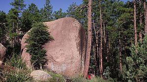
well established loop with views & options by donqcryer   Overview OverviewThis lasso hike is much more than a nice short established hiking and mountain bike lasso trail with great views that descends into Stewart Pocket and Granite Dells. This trail is a connector trail that connects all trails inside Stewart Pocket with the miles of trails Southeast of Stewart Ridge. It starts at the Tonto National Forest Mud Springs Trailhead (aka PATS Round Valley Trailhead) at the S Gibson Court cul-de-sac off of East Phoenix Street. There are many intersections off this trail especially in Stewart Pocket that connect with all the trails from the end of the E. Phoenix Street cul-de-sac trailhead, so one can tailor many trail options and lengths. The loop section goes around a mountain bike park with a labyrinth of trails, bridges, jumps, slickrock, etc. At the far eastern end of the loop, it briefly overlaps the western part of the Stewart Pocket South loop. Thus for a 4.5-mile hike, make this a lasso figure 8 trail! Using this connector, the trail possibilities are plentiful! Payson's mtn bike forest gnomes did a fantastic job of constructing and maintaining this trail... Enjoy!
When the two new developments in Stewart Pocket were approved, and infrastructure (roads, etc.) were put in, many old trails following Mud springs and Stewart Creek were gone or were now on private land. The Tonto Forest Gnomes built a whole network of excellent trails, now on public lands, to circumvent the developed private property. Hike Starting at the trailhead, head south & up on the Round Valley trail for about 50 yards to the National Forest boundary (fence, etc.). Take a hard left onto the trail right inside the NF fence line. The trail is now well established, except over the slickrock outcroppings, all the way down to Stewart Pocket trails. The trail over the slickrock is discernible from a distance. After a 1/4 mile, there is an intersection to the right that goes up to (steeply!) the Stewart Ridge trail for some of the best views in Payson. The trail has switchbacks, and at one, begins the upper bypass trail, so go right (7/4/22 for 25' trail is work-in-progress.) This upper bypass trail has great views and reconnects to the old and well established outer loop trail in Stewart Pocket. Following this loop, you have intersections with all the other trails in the area. After returning to the eastern end of the Stewart Pocket loop (after a huge 30' boulder and over a small wooden bridge), you come to a 4 way intersection. (Going right, the old trail goes on to private propert and is closed. Going left continues west on the Stewart Pocket loop.) Go straight and up on the new-ish (June 2022) lower bypass trail. It will go up and over the rock outcropping and inside the NF fence boundary before rejoining the old trail. Go left (west) and up-ish on the old trail. (The old original trail was here before the 2 new developments and inadvertantly clipped private property for a couple hundred feet. This short section is now posted "No Trespassing" and closed.) BTW, Stewart Pocket is a mountain bike park with a maze of trails, bridges, jumps, and slickrock. One of the north spurs in this loop goes to the PATS Cypress TH on the E. Phoenix Str cul-de-sac. The latter being the Stewart Pocket South Lasso trail, which you will now overlap for a few hundred yards. After turning left / east the trail begins climbing up the ridge with switchbacks and soon you pass the upper bypass intersection on your way back to the trailhead Water Sources seasonal streams and springs Camping National Forest baby, but camping is not popular in the vicinity. Check out the Official Route and Triplogs. Leave No Trace and +Add a Triplog after your hike to support this local community. | |||||||||||||||||||||||||||||||||||||||||||||||||||||||||||||||||||||||||||||||||||||||||||||||||||||||||||||||||||||||||||||||||||||||||||||||||||||||||||||||||||||||||||||||||||||||||||||||||||