Route Editor

| Guide | ♦ | 6 Triplogs | 0 Topics |
details | drive | permit | forecast | route |
stats |
photos | triplogs | topics | location |
| 92 | 6 | 0 |
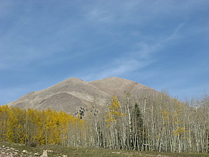
Peel back Peale's summit by Jim If you've come to hike Mount Peale, you will probably drive to La Sal Pass. You can either leave from the pass, or hike back about 1/2 mile on the road to a two track road numbered "4725". If you choose to leave from the pass, hike up towards Peale and a large prominent gully to the west of the main body of the peak. If you choose to hike down the road, do so and then take FR 4725 past the cabin and continue up hill to the two track's rough end, and look for the cairns and social trail which drop out of the forest below the large gully. Either way, you're looking to get below the gully, as the talus covered slopes are not fun and you want to get up on the ridge in a safe manner. The gully offers the best and most worn option.
Once on the ridge, there is a noticeable trail which continues across to the summit. It passes just below the false summit and more or less goes all the way to the wind shelter on the true summit at 12,721'. Views are quite good, but western ones are blocked by the mountain to the west, Mount Tukuhnikivatz. You can either descend the way you came, or make the class 3 traverse to the Mount Tukuhnikivatz. That mountain's east approach face is far less traveled and the talus harder to get by, but worth the effort. Check out the Official Route and Triplogs. Leave No Trace and +Add a Triplog after your hike to support this local community. | |||||||||||||||||||||||||||||||||||||||||||||||||||||||||||||||||||||||||||||||||||||