username
X
password
register
for free!
help
 
   🔥

Willow Creek Loop North - Granite Basin, AZ

Guide 10 Triplogs  0 Topics
  3 of 5  
Fav
Wish
1
details
drive
permit
forecast
🔥
route  
stats
photos
triplogs
topics
location
0 10 0
HAZ reminds you to respect the ruins. Please read the Archaeological Resources Protection Act of 1979 & Ruins Etiquette
Statistics
tap row or icons for details
Difficulty 1 of 5
Route Finding 1 of 5
Distance Lasso-Loop 4.5 miles
Trailhead Elevation 5,196 feet
Elevation Gain 1 feet
Accumulated Gain 530 feet
Kokopelli Seeds 7.15
 Interest Ruins & Historic
 Backpack No
feature photo
Photos Viewed All MineFollowing
Will recalculate on button tap!
10  2016-10-16
Willow Trail #347
mazatzal
10  2015-04-18
Willow Trail #347
mazatzal
25  2015-04-04
Granite Mtn 7185 & 7626 via Williamson Valley
The_Eagle
8  2014-05-11
Willow Trail #347
mazatzal
8  2013-09-29
Willow Trail #347
mazatzal
Author
author avatar Guides 47
Routes 96
Photos 850
Trips 385 map ( 2,948 miles )
Age 81 Male Gender
Location Phoenix, AZ
Associated Areas
list map done
Prescott Region
Historical Weather
Trailhead Forecast
Radar Map
Expand Map
Preferred Apr, Oct, Nov, Mar → 9 AM
Seasons   Spring to Autumn
Sun  6:06am - 6:51pm
Official Route
 
1 Alternative
 
Historic Fire Perimetersacres
🔥 2018 Stubbs Fire34.7 mi**
🔥 2013 Doce Fire23.8 mi*
🔥 View (All) - over Official Route 🔥
*perimeter length in miles
**possible voids inflate figure


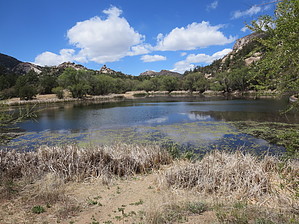
Short Trip to the Ruins
by MEWhiteman

 
Overview
Willow Creek Loop North is in the northeast section of the Granite Basin Recreation Area and provides access to trails #345 and #347 without paying a fee. It includes a pasture, some hills and rocks, and Native American ruins. It is easy hiking through a lovely area and is combinable with Willow Creek Loop (#347 & #345), for a longer hike. All junctions of named and numbered trails are marked.


Hike
The trail begins at the southwest corner of the parking area. I've described the hike in the clockwise direction, though you could hike the loop in either direction. At the Willow Trail #347 junction and the Tin Trough Springs Trail #308, N34 39.403 W112 31.114, keep to the trail on the left, #347. Follow this for 1.25 miles through a pasture area on the right and in the back of houses on the left to a gate and the junction of trail #347 and Mint Wash Trail #345. Go through the gate and continue on trail #347 for 0.28 miles to a spur trail on the left at N34 38.309 W112 31.294. Take this trail 0.16 miles to the Janet Site with Native American ruins. Be careful not to disturb anything while exploring this hilltop area.
remove free decal offer
Return to trail #347 by the spur trail and then back to the gate via #347. Be sure to pass through the gate to reach the junction of trails #347 and #345. There is a junction of these trails just before you reach the gate, but this end of trail #345 takes you to Granite Basin Lake rather than back to the trailhead where you left your car. So pass through the gate and at the junction of trails #347 and #345 go left. Hike 1.25 miles over a hilly area with Granite Mountain to the west (left if you hike the loop clockwise). Two unmarked trails are coming in from the east as you hike, which I think are part of a side trail that follows the top of the hill, but I didn't explore them and so don't know for sure. The junction of trails #345 and #308 that you need to return to the trailhead is well marked at N34 39.278 W112 31.948. Turn right here and follow a wide, smooth trail 1.0 mile back to the trailhead. When I did this in late September, the fields were yellow with wildflowers. Gorgeous!

Gate Policy: If a gate is closed upon arrival, leave it closed after you go through. If it is open, leave it open. Leaving a closed gate open may put cattle in danger. Closing an open gate may cut them off from water. Please be respectful, leave gates as found. The exception is signage on the gate directing you otherwise.

2012-09-28 MEWhiteman


    Check out the Official Route and Triplogs.
    Leave No Trace and +Add a Triplog after your hike to support this local community.
    WARNING! Hiking and outdoor related sports can be dangerous. Be responsible and prepare for the trip. Study the area you are entering and plan accordingly. Dress for the current and unexpected weather changes. Take plenty of water. Never go alone. Make an itinerary with your plan(s), route(s), destination(s) and expected return time. Give your itinerary to trusted family and/or friends.

     Permit $$
    None

    Prescott Forest
    Prescott National Forest Pass

    Only trailheads with six "amenities" have fees. Amenities are picnic tables, trash, toilet, parking, interpretive signing and security.


     Directions
    or
     Road
    Paved - Car Okay

    To hike
    When entering Prescott stay right on SR89, which is Sheldon St. Follow Sheldon St. to the 'T' intersection at Montezuma St. and turn right. Montezuma turns into Whipple, which turns into Iron Springs Rd. (St Rt 10). Continue on this road for 2.9 miles from the turn from Sheldon St. and turn right on Williamson Valley Road (WVR). Continue on WVR for 6.5 miles to the Williamson Valley Trailhead and Park and Ride. There is plenty of parking here as well as a bathroom.
    page created by MEWhiteman on Sep 27 2012 10:16 pm
     90+° 8am - 6pm kills
    helpcorrectionissue

    end of page marker