Route Editor

| Guide | ♦ | 2 Triplogs | 0 Topics |
details | drive | no permit | forecast | 🔥 route |
stats |
photos | triplogs | topics | location |
| 5 | 2 | 0 |
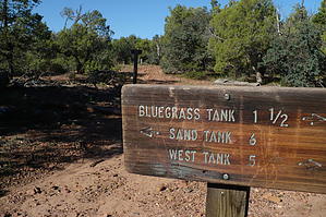
Howling Experience by TrekSafari   The entire trail is a loop about 13 miles long. I have hiked it as two smaller loops. The entire trail is a loop about 13 miles long. I have hiked it as two smaller loops.East Loop gps route I follow the Blue markers to Bluegrass Tank. The Blue continued westward near the tank. But where was I? It was time to head towards the east and home. I suggest walking the loop clockwise.
The trail is a 5.4-mile loop with an elevation varying from 6,240’ to 6,450’. West Loop A sign along the road declares the there had been a forest fire here in the summer of 2002. There was little evidence of any Ghost of the Coyote Trail. I found an off-the-road parking space near an old corral. This path follows portions of old logging roads through pinyon & juniper woodlands. This region of the Apache-Sitgreaves Forest was severely burnt in 2002, and it had not recovered as of 2012. In the summer, this region can be hot and dry. This is a 3.3-mile loop with an elevation varying from 6,300’ to 6,390’. Check out the Official Route and Triplogs. Leave No Trace and +Add a Triplog after your hike to support this local community. | |||||||||||||||||||||||||||||||||||||||||||||||||||||||||||||||||||||||||||||||||