Route Editor

| Guide | ♦ | 2 Triplogs | 0 Topics |
details | drive | permit | forecast | route |
stats |
photos | triplogs | topics | location |
| 12 | 2 | 0 |
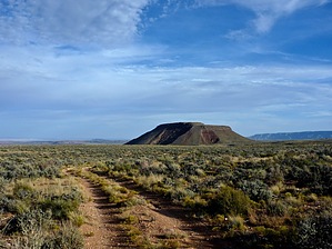
The gold surrounded by a rainbow of color by chumley  You would have to be here for another reason because this is not a destination most people would consider worth the effort required to get to. It's a prominent hill in the middle of a vast plateau and offers expansive views in all directions. Desert View and Cedar Mountain to the southwest; Comanche Point to the west; Cape Solitude, Chuar Butte and the North Rim to the north; and the Little Colorado River Gorge from the northeast to southeast. You would have to be here for another reason because this is not a destination most people would consider worth the effort required to get to. It's a prominent hill in the middle of a vast plateau and offers expansive views in all directions. Desert View and Cedar Mountain to the southwest; Comanche Point to the west; Cape Solitude, Chuar Butte and the North Rim to the north; and the Little Colorado River Gorge from the northeast to southeast.This is deep in the Navajo Nation, and the roads are unmaintained and rough. Gold Hill is just a couple of miles from the "trailhead" for the route down to Blue Spring in the LCR and the farthest you can get via vehicle out toward Cape Solitude. So if either of those are your destination, Gold Hill makes a nice side hike.
Most of the top of the mountain features a rocky ledge of 20-30 feet, inaccessible without climbing. But on this eastern approach, the ledge is broken with fallen boulders that offer several easy routes to the top. The mountain is flat-topped and offers an opportunity to walk the circumference to see all the views. To the south, you can spy the long double-track road you drove in on as well as a lonely Navajo Hogan on the plains. Take in the views (binoculars would be a great accessory), take a break and have a snack, and head back down the way you came! Check out the Official Route and Triplogs. Leave No Trace and +Add a Triplog after your hike to support this local community. | |||||||||||||||||||||||||||||||||||||||||||||||||||||||||||||||||||||||||||||||||||||