Route Editor

| Guide | 0 Triplogs | 1 Topic |
details | drive | permit | forecast | route |
stats |
photos | triplogs | topic | location |
| 18 | 0 | 1 |
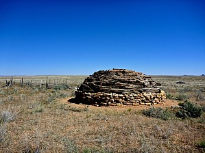
The road less traveled by chumley   What WhatIndian Route 6140 is a north-south route on the Navajo Reservation generally paralleling the eastern boundary of Grand Canyon National Park between Cameron and Cape Solitude. Why Its primary purpose is to provide access to the "trailhead" for the Blue Springs Route into the Lower Colorado River Gorge (LCR), the closest hiking access to Cape Solitude, and for exploring the historic hogans and corrals that dot the plateau of the Navajo Reservation.
This road is in an extremely remote area. Traveling it alone is not recommended. Bring plenty of water and plan for a breakdown. Cellular service is spotty at best. Be prepared for any situation. Description Begin on the Kaibab National Forest road system by turning off the paved AZ-64 approximately 24.5 miles from Cameron. The route follows several different FS roads, most of which are not numbered. But this route is the most traveled and generally easy to choose when a fork or turn presents a dilemma. The first five miles are generally easy driving on graded forest roads leading to an excellent view from the top of the Coconino Rim, looking down onto the plateau and the walls of the LCR gorge. Here the road deteriorates as it descends several switchbacks downhill into the Lower Basin, dropping 800 feet in about a mile. Near the bottom of the switchbacks, the road crosses the FS/Reservation boundary and officially becomes route 6140. From here, the first couple of miles in the Lower Basin features some rocky traverses before smoothing out for the next few miles. At about the 14-mile mark, the road enters Straight Canyon, where it gets generally pretty rough for 3 miles before a short respite just south of Gold Hill. A very rough road turns left up toward Gold Hill, but this can be bypassed by staying to the right at about mile 18. At mile 19.5 there is a T intersection. From here, go left to get to the Cape Solitude trail (about 4 more miles) where it parallels the NPS/Reservation boundary, or go right to access the Blue Springs access point (about 2 miles). This trip will take at least 2.5 hours, or longer if you stop to explore any of the interesting rock structures, corrals, and hogans, or any of the beautiful landscape you traverse. More Info This route can alternately be accessed by traveling from Desert View and around Cedar Mountain via an unmaintained National Park road, joining Route 6140 near Cedar Canyon at about mile 12.5 on the route explained above. This alternate route is several miles shorter, but the road down from Desert View and around Cedar Mountain is considerably more difficult. The savings in mileage will likely not be reflected in a shorter trip time. Please make sure to consult the GPS track for this route for further assistance. Check out the Official Route. Leave No Trace and +Add a Triplog after your 4x4 trip to support this local community. | |||||||||||||||||||||||||||||||||||||||||||||||||||||||||||||||||||||||||||||||||||||||||