 Route Editor

| Guide | ♦ | 19 Triplogs | 0 Topics |
details | drive | permit | forecast | 🔥 route |
stats |
photos | triplogs | topics | location |
| 163 | 19 | 0 |
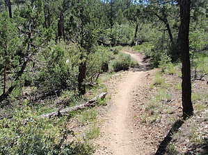
Winding Its Way Up the Hill by MEWhiteman   Overview OverviewThe Wolverton Mountain Trail (#9415) is part of the Prescott Circle Trail and connects the Goldwater Lake Trail (#396) with the Aspen Creek Trail (#48). It is a mostly single track through pine forest and low scrub which gradually climbs by White Spar and Wolverton Mountain gaining 1,000 feet along the way with lots of views. It is easy to follow marked by brown carsonite signs displaying "9415" and the climbing is gradual but steady. Hike From the road begin a long, gradual climb. Early on you'll be hiking through a thin pine forest. The trail winds around a lot as it gains elevation. Soon you'll leave the sounds of traffic behind. You'll cross several old tracks along the early part of the trail; just go directly across each to stay on the trail. At about 0.6 miles you begin to lose a little elevation. At 0.74 miles (N34 30.550 W112 29.015) keep left to avoid a non-designated trail (NDT) coming in from the right and begin climbing again. At 0.92 miles (N34 30.432 W112 29.114) bear right to avoid the NDT. At 1.33 miles (N34 30.649 W112 29.154) you cross a dirt road which is FR9707V, Jack Pine Road, that provides motorized access to White Spar. At 1.45 miles leave the pines. The next 1-1/2 miles will provide open views of Prescott and beyond to the north. On a clear day, you can see the San Francisco Peaks and others in the distance. To your left you can see White Spar; it is mostly green with white outcrops near the summit. You gradually hike along the side of White Spar gaining elevation gradually. At 2.98 miles keep left to avoid a faint trail that goes down the hill.
Gate Policy: If a gate is closed upon arrival, leave it closed after you go through. If it is open, leave it open. Leaving a closed gate open may put cattle in danger. Closing an open gate may cut them off from water. Please be respectful, leave gates as found. The exception is signage on the gate directing you otherwise. Check out the Official Route and Triplogs. Leave No Trace and +Add a Triplog after your hike to support this local community. One-Way Notice This hike is listed as One-Way. When hiking several trails on a single "hike", log it with a generic name that describes the hike. Then link the trails traveled, check out the example. | ||||||||||||||||||||||||||||||||||||||||||||||||||||||||||||||||||||||||||||||||||||||||||||||||


