 Route Editor

| Guide | ♦ | 14 Triplogs | 0 Topics |
details | drive | permit | forecast | 🔥 route |
stats |
photos | triplogs | topics | location |
| 53 | 14 | 0 |
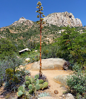
  Like many of the trails in this area, White Rock Spring Trail #39 was originally a road built in the late 1800s to provide horseback access to springs and other cattle waters. The trail passes through mixed chaparral as it traverses an open, exposed landscape between Blair Pass and its junction with Upper Pasture Trail #38. From its highest terrain, there are expansive views of the ranchlands of Skull Valley, and beyond that, distant mountains. Watch for scrub jays hopping through the brush and hummingbirds somersaulting through the air like tiny bejeweled acrobats. Also, keep an eye out for the snakes and lizards that sometimes bask on sun-kissed granite along the trail. Like many of the trails in this area, White Rock Spring Trail #39 was originally a road built in the late 1800s to provide horseback access to springs and other cattle waters. The trail passes through mixed chaparral as it traverses an open, exposed landscape between Blair Pass and its junction with Upper Pasture Trail #38. From its highest terrain, there are expansive views of the ranchlands of Skull Valley, and beyond that, distant mountains. Watch for scrub jays hopping through the brush and hummingbirds somersaulting through the air like tiny bejeweled acrobats. Also, keep an eye out for the snakes and lizards that sometimes bask on sun-kissed granite along the trail.For a pleasant loop hike, take Trail #39 to Upper Pasture Trail #38. Travel east on Trail #38 to its junction with Little Granite Mountain Trail #37. Take Trail #37 north to Blair Pass and the beginning of Trail #39. This loop is approximately 4.5 miles long, not including travel on Granite Mountain Trail #261 (used to access Trail #39). Expect hot, dry conditions during the summer months. There is no reliable drinking water at the trailhead or on the trail. Portions of the trail may be rocky and eroded; please watch your step. Trail access is subject to change with the future implementation of the Williamson Valley-Alto Pit Environmental Assessment. Check out the Official Route and Triplogs. Leave No Trace and +Add a Triplog after your hike to support this local community. One-Way Notice This hike is listed as One-Way. When hiking several trails on a single "hike", log it with a generic name that describes the hike. Then link the trails traveled, check out the example. | |||||||||||||||||||||||||||||||||||||||||||||||||||||||||||||||||||||||||||||||||||||||||||||||||||||||||||||||||||||||||||||||||||||||||||||||||||||||||||||||||||||||||||||||||||||||||||||||||||


