Overview
The Potts Creek Trail (#327) south of Thumb Butte is part of the Prescott Circle Trail (PCT). This trail runs from FR51 to the Cold Spring Trail (#393) and provides the link on the PCT between the Circle Connection Trail (#322) and #393. Initially it followed an old road but has been rerouted in many places onto a single track to avoid eroded areas and to make it more interesting. The hike is completely in a pine forest providing lots of shade and is away from civilization except for one camp seen in the distance near the south end. There are intersections with many other trails in the Thumb Butte area providing opportunities for loop hikes.
The Hike
This hike is described as hiking from FR51 to trail #393. Hike east from the trailhead on FR51 indicated by a carsonite post. All the mileages are measured from this point. Along the way are a couple of dispersed, designated campsites. You reach a gate across the road at 0.12 miles (N34 31.625 W112 32.592). Trail #327 begins at this point. There is parking for a car or two just before the gate. Continue on the road past the gate. At 0.27 miles (N34 31.617 W112 32.448) there is a fork with #327 going to the right. The Thumb Butte Bypass Trail (#326) goes to the left. The first mile of the trail winds back and forth across the road, sometimes following it for short distances, and loses elevation. At 0.57 miles (N34 31.495 W112 32.411) bear right to join the road and at 0.76 miles (N34 31.482 W112 32.226) turn left to leave the road. At 0.96 miles (N34 31.522 W112 32.160) turn sharp left to join the road. At 1.25 miles (N34 31.650 W112 31.963) bear left to leave the road and at 1.28 turn left to join the road again. At 1.39 miles (N34 31.661 W112 31.831) pass the junction with the Circle Connection Trail (#322) which is part of the PCT.
At 1.54 miles (N34 31.688 W112 31.689) pass the junction with the Butte Creek Trail (#321). 0.02 miles after passing this junction turn right to leave the road at an unmarked junction and begin the gradual climb to the end. At 1.71 miles (N34 31.686 W112 31.620) turn right to join the road again. Shortly pass the junction with the Rancho Vista Trail (#387) (N34 31.637 W112 31.574) on the left and 0.06 miles later (N34 31.596 W112 31.593) pass the junction with FR51A on the left. At about 2.3 miles you'll pass an old road on the right. At 2.40 miles (N34 31.211 W112 31.788) turn right onto another unmarked single track leaving the road. At 2.48 miles (N34 31.163 W112 31.785) reach a junction with the High Valley Ranch Trail (#391) and FR9401J. Trail #327 goes just to the right of #391 on a single track. The trail numbers for #327 are on the backs of the carsonite posts for #391 and FR9401J. The trail is now single track to its terminus. At 2.58 miles cross the road. At about 2.7 miles, 3.3 miles, and 3.4 miles cross drainages. At 3.65 miles (N34 30.636 W112 31.881) reach the end of the Potts Creek Trail and the north end of the Cold Spring Trail (#393).
Accumulated elevation gain is 290' southbound and 462' northbound.
Gate Policy: If a gate is closed upon arrival, leave it closed after you go through. If it is open, leave it open. Leaving a closed gate open may put cattle in danger. Closing an open gate may cut them off from water. Please be respectful, leave gates as found. The exception is signage on the gate directing you otherwise.
When hiking several trails on a single "hike", log it with a generic name that describes the hike. Then link the trails traveled, check out the example.
WARNING! Hiking and outdoor related sports can be dangerous. Be responsible and prepare for the trip. Study the area you are entering and plan accordingly. Dress for the current and unexpected weather changes. Take plenty of water. Never go alone. Make an itinerary with your plan(s), route(s), destination(s) and expected return time. Give your itinerary to trusted family and/or friends.
Only trailheads with six "amenities" have fees. Amenities are picnic tables, trash, toilet, parking, interpretive signing and security.
Directions
Road
FR / Dirt Road / Gravel - Car Okay
To hike Directions: From the intersection of Gurley and Montezuma Streets in Prescott, drive west on W. Gurley St. At 1.3 miles bear left on Gurley Street which becomes Thumb Butte Rd. before the next intersection, and continue on Thumb Butte Rd to the trailhead. At 3.3 miles past the Thumb Butte parking area. At 4.1 miles the pavement ends. At 5.2 miles bear left on Thumb Butte (Loop) Rd. avoiding Dearing Park Rd. which bears right. Beyond this point Thumb Butte (Loop) Rd. is not maintained but was passable by car at the time I drove it. At 6.8 miles arrive at the junction with FR51 on the left which provides access to the Potts Creek Trail and has parking for 3 – 4 vehicles.
 Route Editor


 Overview
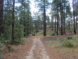


