Route Editor

| Guide | ♦ | 1 Triplog | 0 Topics |
details | drive | no permit | forecast | 🔥 route |
stats |
photos | triplog | topics | location |
| 20 | 1 | 0 |
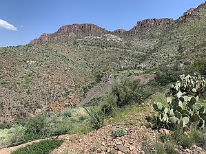
 Overview OverviewThe Belmont mine property was first discovered in 1899, developed over the years, and finally owned by Magma Copper. The Belmont mine has a rich history including the Belmont Hotel in Superior (main street), built by the company. Mineral specimens can be collected from the piles of rock in the area. This is a remote and hidden canyon just south of Apache Leap and many animals and plants can be observed along the hike. Prologue Saw this on a map and found a brief write-up elsewhere on this site. Looked interesting so I plotted a route off of a topo map, uploaded it to my GPS, and went for this hike. The starting point is on Apache Leap Road about 0.89 miles from turning off State Route 177 as we came down 177 from Superior. It is very hard to see the old road off of Apache Leap road. If I didn't have it GPS'ed I'm not sure I'd have found it without some luck.
The hike is entirely uphill except for a couple of very short sections through quartzite, shales, and limestones. It obviously was a road many years ago but now some areas are little more than a game trail while others remain clearly road-like. Most of it is now little more than a very rarely used trail. There are a couple of other mines along the way. I didn't do any exploring of those as they didn't look like much besides tailings. In the sandstones, some good examples of oxidation/reduction concentrations of iron can be seen. When you get to the Belmont mine there is the mine shaft which has a grate over it. There is the headframe that has been pushed over the side into a gulley. There is a hoist house that still has two hoist drum mechanisms in it. There are a couple of water tanks, a tin building which to me looked like it used to be a weight scale.. maybe. Or perhaps a powerhouse.. maybe. Hard to tell. The shaft looks pretty straight down and a rock dropped in it seemed to bottom out in about 3 to 4 seconds. The history of this mine says it was operated between about 1925 to 1945. So presumably the road has had 75 years to revert back to nature. We didn't see any copper wires in any of the remaining stuff that clearly was electrical facilities back in the day. I imagine copper thieves took it. Video A trip to send a camera 300 feet down into the vertical shaft. Check out the Official Route and Triplog. Leave No Trace and +Add a Triplog after your hike to support this local community. | |||||||||||||||||||||||||||||||||||||||||||||||||||||||||||||||||||||||||||||||||||||||||||||||||||||||||||||