 Route Editor

| Guide | ♦ | 8 Triplogs | 1 Topic |
details | drive | permit | forecast | 🔥 route |
stats |
photos | triplogs | topic | location |
| 157 | 8 | 1 |
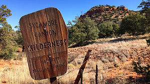
  Overview OverviewUsed mainly for horseback access to the Sycamore Canyon Wilderness. Hikers entering the canyon usually drive to the junction of Trail #53 and Sycamore Basin Trail #63 using Forest Road 181. However, horseback riders usually start their journey into the canyon at Henderson Flat, where both corrals and water for horses are available. Henderson Trail #53 is a level trail that traverses below the red rock cliffs of Sycamore Canyon. The lower third of the trail is the most scenic. Portions of this trail lie within the Sycamore Canyon Wilderness, where motor vehicles and the use of any mechanized equipment, including bicycles, are prohibited. Wilderness is an important resource and national heritage--please, leave no trace. Summer travelers should prepare for hot, dry conditions. Water is available for horses at Sycamore Tank, about 0.5 miles south of the junction with Trail #63. Check out the Official Route and Triplogs. Leave No Trace and +Add a Triplog after your hike to support this local community. One-Way Notice This hike is listed as One-Way. When hiking several trails on a single "hike", log it with a generic name that describes the hike. Then link the trails traveled, check out the example. | ||||||||||||||||||||||||||||||||||||||||||||||||||||||||||||||||||||||||||||||||||||||||||||||||||||||||||||||||||||||||||||||||||||||||||||||||||||||||||||||||||||||||||||||


