 Route Editor

| Guide | ♦ | 2 Triplogs | 0 Topics |
details | drive | permit | forecast | 🔥 route |
stats |
photos | triplogs | topics | location |
| 11 | 2 | 0 |
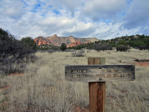
Greetings from the tide by HAZ_Hikebot   Overview: Yew Thicket Trail #52 starts on the Kaibab National Forest in open stands of ponderosa pine and pinyon-juniper woodland. This portion of the trail follows an old roadbed across the canyon rim. At its junction with Lonesome Pocket Trail #61, this trail narrows to a footpath. Here the trail is at its most scenic and most difficult as it descends a steep canyon through red rock bluffs. Yew Thicket Trail #52 continues southwest along a side canyon as it approaches its end at Sycamore Basin Trail #63. Trail #63 is the main thoroughfare through the 55,000-acre Sycamore Canyon Wilderness and presents excellent opportunities for backpacking in this rugged, remote area. Overview: Yew Thicket Trail #52 starts on the Kaibab National Forest in open stands of ponderosa pine and pinyon-juniper woodland. This portion of the trail follows an old roadbed across the canyon rim. At its junction with Lonesome Pocket Trail #61, this trail narrows to a footpath. Here the trail is at its most scenic and most difficult as it descends a steep canyon through red rock bluffs. Yew Thicket Trail #52 continues southwest along a side canyon as it approaches its end at Sycamore Basin Trail #63. Trail #63 is the main thoroughfare through the 55,000-acre Sycamore Canyon Wilderness and presents excellent opportunities for backpacking in this rugged, remote area.
Check out the Official Route and Triplogs. Leave No Trace and +Add a Triplog after your hike to support this local community. One-Way Notice This hike is listed as One-Way. When hiking several trails on a single "hike", log it with a generic name that describes the hike. Then link the trails traveled, check out the example. | |||||||||||||||||||||||||||||||||||||||||||||||||||||||||||||||||||||||||||||||||||


