username
X
password
register
for free!
help
   🔥

Pine Creek Trail #289, AZ

Guide 12 Triplogs  1 Topic
  3 of 5  
Fav
Wish
3
details
drive
permit
forecast
🔥
route  
stats
photos
triplogs
topic
location
157 12 1
Statistics
tap row or icons for details
Difficulty 2.5 of 5
Route Finding 2 of 5
Distance Lasso-Loop 10.91 miles
Trailhead Elevation 5,517 feet
Elevation Gain 1,503 feet
Accumulated Gain 1,602 feet
Avg Time One Way 4.5 hours
Kokopelli Seeds 16.25
 Interest Off-Trail Hiking & Seasonal Creek
unreported if dogs are allowed
editedit > ops > dogs to adjust
feature photo
Photos Viewed All MineFollowing
Will recalculate on button tap!
16  2023-04-22
Big Bug Mesa Wandering
desert_jellyfish
23  2019-06-22
Little Wolf - Pine Creek - Grapevine Loop
joebartels
13  2019-06-22
Little Wolf - Pine Creek - Grapevine Loop
The_Eagle
14  2019-06-22
Little Wolf - Pine Creek - Grapevine Loop
BiFrost
15  2018-09-13
Big Bug Mesa
kingsnake
41  2014-10-17 kingsnake
21  2014-07-05
Yankee Doodle Eastern Loop
The_Eagle
15  2013-09-14
BB Mesa-L Wolf Crk-Pine Crk-Grapevine Lp
The_Eagle
Page 1,  2
Author
author avatar Guides 116
Routes 337
Photos 11,399
Trips 894 map ( 8,139 miles )
Age 63 Male Gender
Location Sunnyslope, PHX
Associated Areas
list map done
Prescott Region
Historical Weather
Trailhead Forecast
Radar Map
Expand Map
Preferred Apr, Oct, May, Mar → 8 AM
Sun  6:05am - 6:50pm
Official Route & 1 Rt
 
9 Alternative
 
Historic Fire Perimeteracres
🔥 2017 Goodwin Fire49.0 mi*


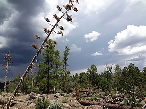
Never trust a map
by kingsnake

I will describe this hike in three segments: 1) Pine Creek Trail #289, 2) exploring the southern end of Big Bug Mesa, and 3) descending Pine Creek from the line shack to Seaton Spring.


Pine Creek Trail #289: The trail is a decent surface the first two miles, but crosses Pine Creek many times, and is slightly up & down though, obviously, tending up. At 0.4 miles, on your left, will be a junk pile. At 1.1 miles, on your left, will be a corrugated metal tank, with two probably dry tanks made of metal, lined on the inside with stone & concrete. At 2.6 miles, will be the unusual triple box metal tank. All three boxes were full of decent water when I saw them, and one was trickling over, so they were receiving freshwater. The trail is now on the west side of the creek and beginning its climb to the rim. In less than a hundred yards, on the east side of the creek, if you look closely, you will see a small metal box: Just on the other side, the box is Seaton Spring. The box was full of decent water when I saw it. Now beware, despite what FS Topo and Topo would have you believe, I could find no evidence that the trail continues north up Pine Creek. Instead, it turns left/west and gets steep, and slippery with pebble gravel. At 3.0 miles you will hit the rim, not far from the small stone wall. Though I did not see any dirt bikes, keep an eye out for them as they have left tracks on Trail #289.
remove free decal offer
Explore: There are numerous jeep trails on the southern end of Big Bug Mesa. Lots of fire rings too. I followed a jeep trail for a while, then cut cross country towards Hill 7020. Cross country travel varies from stony (both granite and what appears to be volcanic), to deadfall riddled, to smooth grass. No matter which, it's pretty smooth sailing. Just before Hill 7020, there is a trail heading left / west, and down. I did not follow it the whole way, but it appears to head down towards Old Dandrea Ranch. Hill 7020 has great views of Moscow Peak, Mount Union, Mount Davis, and Turkey Creek. You can even see the San Francisco Peaks in the far distance! I saw no other hiking trails in the area but instead followed another jeep trail east, to the rim overlooking Wolf Creek. More great views. The line shack used to just be a shack, but the house ruins -- surrounded by an amazing amount of junk spread over several acres -- used to be a nice house. Not sure what happened, but shame it ended up that way. Too collapsed to look inside. There are lots of fences and gate-less gates in the area.

Descending Pine Creek: From the line shack, you have two choices: 1) either work your way west, then southwest, along the rim for a mile back to the top of Trail #289 at the stone wall, then diddy bop on down, or 2) drop into Pine Creek and scramble the next half mile to Seaton Spring. As I said earlier, there is no evidence of any trail between the line shack and Seaton Spring. Side-sloping also was not practical the couple of times I tried it. Despite the creek bottom being choked with rocks, much deadfall, and even a few more barbwire fences, the creek bottom is your best route if you drop into the canyon. It's only about 0.3 miles to Seaton Spring, but your track will be twice that distance due to dodging & weaving. Cross Pine Creek at Seaton Spring, hop back on Trail #289, then book back to the trailhead.

Note: There are two tracks on my uploaded route: The first track for the actual path Trail #289 follows -- as opposed to the misdirection claimed by FS Topo and Topo -- and the second track for exploring the mesa, then returning via Pine Creek.

Gate Policy: If a gate is closed upon arrival, leave it closed after you go through. If it is open, leave it open. Leaving a closed gate open may put cattle in danger. Closing an open gate may cut them off from water. Please be respectful, leave gates as found. The exception is signage on the gate directing you otherwise.

2014-10-18 kingsnake


    Check out the Official Route and Triplogs.
    Leave No Trace and +Add a Triplog after your hike to support this local community.

    One-Way Notice
    This hike is listed as One-Way.

    When hiking several trails on a single "hike", log it with a generic name that describes the hike. Then link the trails traveled, check out the example.
    WARNING! Hiking and outdoor related sports can be dangerous. Be responsible and prepare for the trip. Study the area you are entering and plan accordingly. Dress for the current and unexpected weather changes. Take plenty of water. Never go alone. Make an itinerary with your plan(s), route(s), destination(s) and expected return time. Give your itinerary to trusted family and/or friends.

     Permit $$
    None

    Prescott Forest
    Prescott National Forest Pass

    Only trailheads with six "amenities" have fees. Amenities are picnic tables, trash, toilet, parking, interpretive signing and security.


     Directions
    or
     Road
    FR / Jeep Road - Car possible when dry

    To hike
    From Phoenix: North on I-17 to the Cordes Junction exit. West 7.5 miles on AZ 69 to Mayer. Left at the Circle K (Central Ave.), bend right. First left onto Miami St. First right onto Wicks Ave., bending left. In 0.2 mile, left onto Jefferson St. In about a mile, you will cross a cattle gate, and the road will turn from pavement to dirt. In about 9 miles, you will see an "Entering Private Property" sign. That's the hamlet of Pine Flat. As soon as you pass the last "No Trespassing" sign, on the right will be a very small pull-out, park there, it is where Trail #289 starts. FR 67 is narrow & twisty, but smooth. (Much smoother than Aravaipa Rd.) There are a few bumpy spots and a creek crossing, but a car should be okay in dry weather, with some caution. I had two oncoming vehicles both heading out & back in, so take care approaching curves.
    page created by joebartels on Oct 18 2014 4:04 pm
     90+° 8am - 6pm kills
    helpcorrectionissue

    end of page marker