username
X
password
register
for free!
help
   🔥

Clark Spring Trail #40, AZ

Guide 16 Triplogs  0 Topics
  3 of 5  
Fav
Wish
0
details
drive
permit
forecast
🔥
route  
stats
photos
triplogs
topics
location
96 16 0
Statistics
tap row or icons for details
Difficulty 2.5 of 5
Distance One Way 2.1 miles
Trailhead Elevation 5,626 feet
Elevation Gain 790 feet
Accumulated Gain 791 feet
Kokopelli Seeds 4.74
unreported if dogs are allowed
editedit > ops > dogs to adjust
feature photo
Photos Viewed All MineFollowing
Will recalculate on button tap!
14  2020-08-08 kingsnake
12  2019-08-05
Little Granite Mountain Loop
rayhuston
6  2016-02-20
Granite Mountain Peak 7626
Tough_Boots
20  2015-05-03
Little Granite Mountain Loop
Uberdroog
4  2015-02-06
Tin Trough Springs Trail #308
toddak
5  2013-04-28
Little Granite Mountain Loop
mazatzal
Author
author avatar Guides 16,843
Routes 17,472
Photos 24
Trips 1 map ( 6 miles )
Age 28 Male Gender
Location HAZ, TrailDEX
Associated Areas
list map done
Prescott Region
Historical Weather
Trailhead Forecast
Radar Map
Expand Map
Preferred Apr, Oct, May, Nov
Sun  6:06am - 6:51pm
Official Route & 1 Rt
 
5 Alternative
 
Historic Fire Perimetersacres
🔥 2018 Stubbs Fire34.7 mi**
🔥 2013 Doce Fire23.8 mi*
🔥 View (All) - over Official Route 🔥
*perimeter length in miles
**possible voids inflate figure


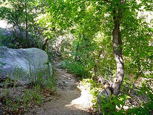
A Griswold favorite
by HAZ_Hikebot

Clark Spring Trail #40 begins in open chaparral near Granite Basin Lake and follows a nearly straight course to the southwest.


It then climbs continuously through ponderosa pine forest to the Clark Spring area. From here, the trail climbs higher through ponderosa, pinyon pine, and Gambel oak to the pass between Two Rock Mountain and Little Granite Mountain where it meets Little Granite Mountain Trail #37. There are good views of the San Francisco Peaks.
remove free decal offer
The Clark Springs Trail #40 provides campers at Granite Basin Recreation Area with a day trip along an attractive riparian corridor to Clark Spring.

2018-07-14 HAZ_Hikebot


    Check out the Official Route and Triplogs.
    Leave No Trace and +Add a Triplog after your hike to support this local community.

    One-Way Notice
    This hike is listed as One-Way.

    When hiking several trails on a single "hike", log it with a generic name that describes the hike. Then link the trails traveled, check out the example.
    WARNING! Hiking and outdoor related sports can be dangerous. Be responsible and prepare for the trip. Study the area you are entering and plan accordingly. Dress for the current and unexpected weather changes. Take plenty of water. Never go alone. Make an itinerary with your plan(s), route(s), destination(s) and expected return time. Give your itinerary to trusted family and/or friends.

     Permit $$
    no fees or permits reported

    if incorrect tell us about it

    Prescott Forest
    Prescott National Forest Pass

    Only trailheads with six "amenities" have fees. Amenities are picnic tables, trash, toilet, parking, interpretive signing and security.


     Directions
    or
     Road


    To hike
    From its intersection with Willow Creek Road, travel northwest on Iron Springs Road for 3 miles. Turn right onto Granite Basin Road and proceed 3.5 miles to the Metate Parking Area on the left. There is parking for 20 vehicles. Road conditions are paved.

    Horse trailers must park at the Cayuse Equestrian Trailhead.
    page created by joebartels on Nov 19 2012 1:22 pm
     90+° 8am - 6pm kills
    helpcorrectionissue

    end of page marker