 Route Editor

| Guide | ♦ | 1 Triplog | 0 Topics |
details | drive | permit | forecast | 🔥 route |
stats |
photos | triplog | topics | location |
| 0 | 1 | 0 |
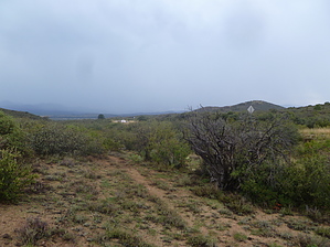
Perl Charles with less traffic and more rain by kingsnake   I hiked south from FR 71 / White Spar Windmill. FR 71 to the north end of the trail is the nicest forest road you could ever hope to drive. Note that the windmill no longer exists: There's just two concrete tanks, one large, one small. I hiked south from FR 71 / White Spar Windmill. FR 71 to the north end of the trail is the nicest forest road you could ever hope to drive. Note that the windmill no longer exists: There's just two concrete tanks, one large, one small.From the tank, take a sharp right up a narrow, sandy wash trail. After a couple hundred yards, you will emerge next to Hwy 89. I mean, right next to it. Just a few yards away. It's like hiking on Perl Charles next to Hwy 51, but with less traffic. You can see Wilhoit, about 1.5 miles south.
The wash parallels the trail for another .25 miles, before the wash turns south, while the trail continues southwest. At that 1.0 mile point, you could make a short climb back up to the trail, or stay in the wash as it bends away. The further south the wash goes, the deeper, rockier, and more brush-strewn it gets. But at its worst, it's still not bad. The biggest "scramble" is maybe five feet, and if the brush gets too dense, it is easy to find cattle paths around it. (There's a lot of cow poo in the wash.) Your next decision point is at 1.6 miles: 1) Stay in the wash as it continues south another half mile to Orofino Windmill, or 2) climb west out of the wash to FR 72. Again, I chose door #2. The climb is only 100 feet, but rather steep and slippery. On the other side of the ridge, at 1.8 total miles, you will hit FR 72. From there it is .25 miles to the south end of official Orofino #107, and from there .75 miles up to the intersection with Hwy 89. ----- The official Orofino #107 is only 1.7 miles long, not even worth driving from Prescott to hike, let alone Phoenix -- especially considering that at least half of it is right next to the highway. What I recommend doing instead, hiking Glen Oaks #118 to Telegraph Springs, then east on FR 9402 / FR 71 to White Spar Windmill, then south on Orofino #107 into the wash, for a 6-7 mile one-way hike. Or do the opposite, but start from Orofino Windmill. Check out the Official Route and Triplog. Leave No Trace and +Add a Triplog after your hike to support this local community. One-Way Notice This hike is listed as One-Way. When hiking several trails on a single "hike", log it with a generic name that describes the hike. Then link the trails traveled, check out the example. | |||||||||||||||||||||||||||||||||||||||||||||||||||||||||||||||||||||||||||||||||||||||||||


