The Gila wilderness is the second largest wilderness area in the continental United states after the Bob Marshal. Many from Tucson run to the White Mountains, not realizing that for the same amount of time in the car you can be in one of the most remote and pristine wildernesses in the country. You can wander for days through high ponderosa covered mountains and not see a sole. The Meadows is a wide spot in a 1000 ft deep canyon on the Middle Fork of the Gila River. Yes, the same dry Gila south of Phoenix. Here the headwaters run year round. Like any adventure getting there is half the problem. There are three common ways to get there. One starts at the Gila Cliff Dwellings visitor center and goes right up the Middle Fork of the Gila and involves at least 30 creek crossings that can really get old when there is a lot of water. The second involves cutting the crossings in half by taking a shortcut though Little Bear Canyon, which is a slot canyon that enters the main canyon just below Jordan Hot Springs. Tthe trail above Jordan hot springs can be marginal at times. We chose the third option that has about a thousand feet of elevation gain, better trail and no water crossings. The problem is that the portion of the trail from the Little Bear trail to the Lilly park trail does not appear on your TOPO map. This is common in the Gila. Some trials get little use then a packer comes along and changes the route and like magic you have a new route for the trail, not on the map. The best map is the official forest service map purchased online from the government or at the visitor center. The rangers at the visitor center are also very helpful and knowledgeable and don't mind talking on the phone.
The trailhead is located at the TJ corral campground about a mile west of the visitor center on the way to the Gila cliff dwellings. The Little Bear canyon trail (#729) climbs out of the valley on the north side of the parking lot through meadows of juniper trees. It passes through several fence lines and into the wilderness. This trail will take you to little bear canyon, but we turned off after about 2 miles before it begins to drop into the middle fork.
We went west of the Lilly Park trail (#164) that gradually climbed through the Juniper and into ponderosa pine forest. For most of the way the trail follows a ridgeline, giving you magnificent views of the enormity of the Gila. The Baldy peaks are visible in the distance. After 4 miles it intersects the meadows trail( #28) that comes up from the west for after a steep climb. Turn right and after a few more miles turn right again and stay on the meadows trail as the Lilly park trail goes to the left. Soon after this turn the trail drops 1000 feet in about a mile to the canyon floor. The Meadow is on both sides of the creek with numerous campsites. My favorite is on the east side where the stream leaves the meadow. Easy water, flat out of the way with good tree cover.
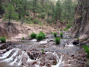
The next day we went up the Middle Fork about 4 miles to what is called "The Narrows" which is a series of rapids and small pools in obviously a narrow part of the canyon. The trail up the canyon further into the wilderness for some reason was better than the trail down the canyon. The trail down the canyon entered a area of beaver ponds and became a test of how much mud we could bushwhack though. We decided it would be more fun to lie around camp and rest up for the 1000 foot climb out of the canyon.
When hiking several trails on a single "hike", log it with a generic name that describes the hike. Then link the trails traveled, check out the example.
WARNING! Hiking and outdoor related sports can be dangerous. Be responsible and prepare for the trip. Study the area you are entering and plan accordingly. Dress for the current and unexpected weather changes. Take plenty of water. Never go alone. Make an itinerary with your plan(s), route(s), destination(s) and expected return time. Give your itinerary to trusted family and/or friends.
Permit $$
None
Directions
Road
Paved - Car Okay
To hike From Tucson take I-10 East 153 miles east to Lordsburg, MN Follow sign to NM 90 north to Silver City. 41 miles. Take State Highway 15 north from Silver City. Although the distance from Silver City is only 44 miles, the travel time is approximately two hours due to twisting and winding mountain terrain. An alternative route from Silver City is along State Highway 35 and goes through the Mimbres Valley. Even though it is 25 miles longer than Highway 15, it is less winding, wider, more level, and easier to travel; therefore it takes about the same amount of time to drive. NOTE: If your vehicle, travel trailer, or RV is over 20 feet in length, you should take Highway 35. TJ Corral Trailhead is located between the visitor center and the Cliff Dwellings a mile west of the center.
 Route Editor


