 Route Editor

| Guide | ♦ | 8 Triplogs | 0 Topics |
details | drive | permit | forecast | 🔥 route |
stats |
photos | triplogs | topics | location |
| 26 | 8 | 0 |
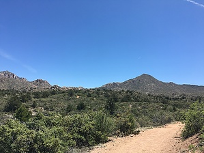
Up is always better by HAZ_Hikebot   Like many of the trails in this area, Upper Pasture Trail #38 was originally a road built in the late 1800s to provide horseback access to springs and other cattle waters. Evidence of this history is marked by an old horse trough beside the trail, slowly turning to rust with the elements' rhythm. This trail stays in pinyon-juniper woodland and mixed chaparral. Watch for scrub jays and towhees moving from branch to branch. Wildflowers of every color, including creamy yarrow and bright red penstemon, grow along the path. Large granite boulders balanced at precarious angles throw shadows across the landscape. However, the best shade along this route is found under the boughs of a few large alligator junipers that provide enticing spots to take a break and enjoy the view of Little Granite Mountain. Like many of the trails in this area, Upper Pasture Trail #38 was originally a road built in the late 1800s to provide horseback access to springs and other cattle waters. Evidence of this history is marked by an old horse trough beside the trail, slowly turning to rust with the elements' rhythm. This trail stays in pinyon-juniper woodland and mixed chaparral. Watch for scrub jays and towhees moving from branch to branch. Wildflowers of every color, including creamy yarrow and bright red penstemon, grow along the path. Large granite boulders balanced at precarious angles throw shadows across the landscape. However, the best shade along this route is found under the boughs of a few large alligator junipers that provide enticing spots to take a break and enjoy the view of Little Granite Mountain.Expect hot, dry conditions during the summer months. There is no reliable drinking water at the trailhead or on the trail. This area is home to several species of rattlesnakes—please watch your step and never handle wildlife. As of August 2010, the trail is severely eroded along much of its length and is unsuitable for mountain biking. Trail access is subject to change with the future implementation of the Williamson Valley-Alto Pit Environmental Assessment.
Visitors are asked to be alert and stay on existing trails when recreating on Granite Mountain as the area recovers from the Doce Fire of 2013. Soil erosion has occurred on portions of the trails, thus exposing more rock. Cross-country travel increases the possibility of encountering rolling rocks, stump and root holes, falling trees, and loose soils from rains. Check out the Official Route and Triplogs. Leave No Trace and +Add a Triplog after your hike to support this local community. One-Way Notice This hike is listed as One-Way. When hiking several trails on a single "hike", log it with a generic name that describes the hike. Then link the trails traveled, check out the example. | |||||||||||||||||||||||||||||||||||||||||||||||||||||||||||||||||||||||||||||||||||||||||||||||||||||||||||||||||||||||||||||||||||||||||||||||||||||||||||||||||||||||||||||||||


