 Route Editor

| Guide | ♦ | 2 Triplogs | 0 Topics |
details | drive | permit | forecast | 🔥 route |
stats |
photos | triplogs | topics | location |
| 0 | 2 | 0 |
serve chilled by kingsnake   There are several jeep trails leading west from the large black gravel pullout on Hwy 89. Take the jeep trail that goes past the cattle chute. About 50 yards up the trail, you will see the actual "118" trail sign. The entire trail 2.3 miles to Telegraph Springs is a jeep trail. In some spots, decent track, in many others requiring high clearance 4x4 and some skill. (There are faint tire tracks, indicating it has been driven, but not often.) As far as hiking goes, it is no problem. Dogs and kids could do it. The hike is a steady climb of 400 feet in about 1.1 miles to the Hill 6003 saddle, followed by a 600-foot descent to Telegraph Springs. There are several jeep trails leading west from the large black gravel pullout on Hwy 89. Take the jeep trail that goes past the cattle chute. About 50 yards up the trail, you will see the actual "118" trail sign. The entire trail 2.3 miles to Telegraph Springs is a jeep trail. In some spots, decent track, in many others requiring high clearance 4x4 and some skill. (There are faint tire tracks, indicating it has been driven, but not often.) As far as hiking goes, it is no problem. Dogs and kids could do it. The hike is a steady climb of 400 feet in about 1.1 miles to the Hill 6003 saddle, followed by a 600-foot descent to Telegraph Springs.0.19 mi: Horizontal mine shaft. It looks like it goes back a ways, but I did not explore it.
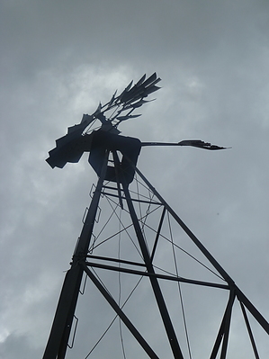
0.35 mi: Supposed location of Glen Oaks Spring. I could not find it. Perhaps the topo people meant the previous concrete shaft. 0.52 mi: Dry concrete tank. Or perhaps they meant this is the spring? It has a metal pipe with big holes and extensive cracks. 1.25 mi: Just after crossing the saddle, you will get your first view of Wilhoit. 2.32 mi: Telegraph Springs consists of a shooting range, a metal tank, a windmill (which makes spooky creaking sounds), a concrete tank, a cattle chute, and a few remains of a corral. At this point, you can turn around and go back, or continue east on FR 9402 towards Hwy 89, cross Hwy 89 onto FR 71, then take Orofino #107 south to the intersection of FR 72 and Hwy 89 for a shuttle total of about 6.5 miles (or an out-and-back of 13.0 miles). Check out the Official Route and Triplogs. Leave No Trace and +Add a Triplog after your hike to support this local community. One-Way Notice This hike is listed as One-Way. When hiking several trails on a single "hike", log it with a generic name that describes the hike. Then link the trails traveled, check out the example. | ||||||||||||||||||||||||||||||||||||||||||||||||||||||||||||||||||||||||||||||||||||||||


