tap row or icons for details
Difficulty
2.5 of 5
Distance One Way
2.85 miles
Trailhead Elevation
6,900 feet
Elevation Gain
659 feet
Accumulated Gain
719 feet
Kokopelli Seeds
5.25
Will recalculate on button tap!
6
2025-08-02 Whiffer
4
2025-07-19
Dandrea and Yankee Doodle Trails
Whiffer
2
2025-07-19 Whiffer
19
2024-05-30
Yankee - Crooks Canyon Figure 8 Loop
joebartels
18
2024-05-30
Yankee - Crooks Canyon figure 8 Loop
The_Eagle
10
2023-10-04
Mount Union - Bradshaw Mountains
TheHikingGolfer
30
2021-09-04
Yankee - Crooks Cyn - Turkey Creek Fig 8 Loop
joebartels
8
2021-09-04
Yankee - Crooks Cyn - Turkey Creek Fig 8 Loop
The_Eagle
Page 1 , 2 , 3 , 4 , 5 , 6
list
map
done
Prescott Region
Historical Weather
Trailhead Forecast Radar Map
Preferred May, Oct, Sep, Apr
Named Locations Coordinate Links
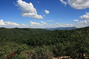
Dandrea Trail #285
Official Route HAZ_Hikebot
2.86 mi
Dandrea Trail #285
2.83 mi
Dandrea Trail #285
1.18 mi
Dandrea Trail #285
3.3 mi
Dandrea Trail #285
1.09 mi
Dandrea and Yankee Doodle Trails
4.62 mi
Yankee - Crooks Canyon Figure 8 Loop
16.74 mi
Yankee - Crooks Canyon figure 8 Loop
17.09 mi
Mount Union - Bradshaw Mountains
14.89 mi
Yankee - Crooks Cyn - Turkey Cree...
18.18 mi
Yankee - Crooks Cyn - Turkey Cree...
18.45 mi
Union - Moscow - Davis
18.62 mi
Davis - Union
6.49 mi
Davis - Moscow - 7675 - Union - S...
15.77 mi
Davis - Moscow - 7675 - Union - S...
16.35 mi
Groom Creek - Bradshaw Four
25 mi
Bradshaw Mountains Trifecta
13.9 mi
Bradshaw Mountains Trifecta
13.88 mi
Mount Union - Bradshaw Mountains
4.36 mi
Bradshaws: Davis Union Spruce
14.12 mi
Mount Union - Bradshaw Mountains
5.13 mi
Mount Union - Mount Davis Trail Run
7.01 mi
Groom Creek-Mt Davis
14.67 mi
Groom Creek-Davis-Union
16.29 mi
Union Davis Loop via Yankee Doodle
6.45 mi
Dave and The Onion
5.88 mi
Spruce - Davis - Union - Tritle S...
18.32 mi
Spruce-Davis-Union-Tritle Shuttle
18.47 mi
Dandrea - Mt Union - Yankee Doodl...
17.35 mi
Dandrea - Yankee Doodle - Senator...
15.18 mi
Groom-Davis
14.47 mi
Yankee Doodle Eastern Loop
38.94 mi
Yankee Doodle Eastern Loop
20.03 mi
Spruce-Davis-Union-Tritle-Maveric...
21.33 mi
Spruce Davis Union Tritle Maveric...
20.15 mi
Mount Union - Bradshaw Mountains
4.74 mi
Arrastra CK #275 & Yankee Doodle ...
11.7 mi
Historic Fire Perimeter acres 🔥 2022-05-02 Crooks 39.4 mi*
Happy
Trails!
One-Way Notice This hike is listed as One-Way.
When hiking several trails on a single "hike", log it with a generic name that describes the hike. Then link the trails traveled, check out the
example .
 Route Editor


