username
X
password
register
for free!
help
  This is likely a great time to hike this trail!  Check out "Preferred" months below, keep in mind this is an estimate. 
  

Going-to-the-Sun-Road, MT

Guide 14 Triplogs  0 Topics
  4.6 of 5  
Fav
Wish
0
details
drive
permit
forecast
map
stats
photos
triplogs
topics
location
321 14 0
Statistics
tap row or icons for details
Distance One Way 50 miles
Trailhead Elevation 4,499 feet
Avg Time One Way 2-4 hours
 Interest Historic, Seasonal Waterfall, Perennial Waterfall, Seasonal Creek, Perennial Creek & Peak
 Backpack Yes & Connecting
 Dogs not allowed
feature photo
Photos Viewed All MineFollowing
51  2022-07-17
Hidden Lake Overlook
tibber
60  2017-08-16
Lake McDonald kayaking and much more
tibber
82  2014-07-18 tibber
44  2012-08-06 tibber
44  2011-07-24 tibber
86  2008-07-11 tibber
65  2005-07-12 tibber
Author
author avatar Guides 48
Routes 510
Photos 9,555
Trips 578 map ( 5,972 miles )
Age 79 Male Gender
Location Scottsdale, AZ
Historical Weather
Trailhead Forecast
Expand Map
Preferred Jun, Sep, Jul, Aug
Seasons   Early Summer to Early Autumn
Sun  5:56am - 7:08pm
0 Route
 
1 Alternative


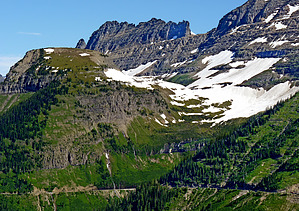
.. 1932 Engineering Marvel ..
by Grasshopper

  Likely In-Season! 
Overview: On July 15,1933, this marvel of engineering wonder was officially dedicated and renamed from the "Transmountain Road" to "Going-to-the-Sun-Road" and has been described ever since as one of the most beautiful fifty (~50) mile pieces of mountain road in the world!


It is estimated that 98% of the visitors to Glacier NP see the park from the Going-to-the-Sun-Road or other roads within the park. Early park naturalist George C. Ruhle, who named this new highway in 1933 stated:
"At first this was primarily a walking and horseback riding park.. Now they skim through it in an automobile and they cling to it like a shipwrecked sailor to a raft."
remove free decal offer
Warning: Because you really won't be keeping your eyes on the road as you drive, the safest and most preferred mode of transportation is the Glacier NP "shuttle service vans" which operate each year from ~July 3rd to September 1st. You can also drive "your own vehicle" or you can also "bike-it"(limited to certain hours of the day).

History: Construction began in 1924 and was completed in 1932 (eight long years to complete). On July 15,2008, the Going-to-the-Sun-Road celebrated its 75th anniversary.

Drive: On the Going-to-the-Sun-Road there are at least 17 stops which include: scenic viewpoints, visitor centers, hotels, shops, bathrooms, campgrounds, boat rides, and day hiking or backpacking trail heads for at least 12 different connecting trail hikes.

Water Sources: Not a problem..

2013-07-16 Grasshopper


    Check out the Triplogs.
    Leave No Trace and +Add a Triplog after your scenic drive to support this local community.
    WARNING! Hiking and outdoor related sports can be dangerous. Be responsible and prepare for the trip. Study the area you are entering and plan accordingly. Dress for the current and unexpected weather changes. Take plenty of water. Never go alone. Make an itinerary with your plan(s), route(s), destination(s) and expected return time. Give your itinerary to trusted family and/or friends.

     Permit $$
    NPS

    Glacier National Park
    $30 per car(week), $12 bike/foot(week), $50 annual View Current Entrance Fees


     Directions
    or
     Road
    Paved - Car Okay

    To scenic drive
    From "either" West Glacier, MT (the GNP-Apgar Transit Station) "or" East Glacier (the GNP-Saint Mary Visitor Center): The Going-to-the-Sun Road starts at either of these two locations and continues for ~50 "jaw-dropping-oou-ah" miles in-between.

    page created by Grasshopper on Jul 16 2013 12:57 pm
     90+° 8am - 6pm kills
    helpcorrectionissue

    end of page marker