username
X
password
register
for free!
help
 
   🔥

Ponderosa Trail #382, AZ

Guide 2 Triplogs  0 Topics
  2.5 of 5  
Fav
Wish
0
details
drive
permit
forecast
🔥
route  
stats
photos
triplogs
topics
location
0 2 0
Statistics
tap row or icons for details
Difficulty 2 of 5
Route Finding 1 of 5
Distance One Way 1.61 miles
Trailhead Elevation 5,621 feet
Elevation Gain 400 feet
Accumulated Gain 450 feet
Avg Time One Way 45 minutes
Kokopelli Seeds 3.11
feature photo
Post the 1st photoset!
Author
author avatar Guides 69
Routes 37
Photos 3,010
Trips 2,387 map ( 14,004 miles )
Age 55 Male Gender
Location Phoenix,Az
Associated Areas
list map done
Prescott Region
Historical Weather
Trailhead Forecast
Radar Map
Expand Map
Preferred Apr, Oct, Nov, Mar → 7 AM
Sun  6:05am - 6:52pm
Official Route
 
2 Alternative
 
Historic Fire Perimetersacres
🔥 2018 Stubbs Fire34.7 mi**
🔥 2002 Indian9.0 mi*
🔥 View (All) - over Official Route 🔥
*perimeter length in miles
**possible voids inflate figure


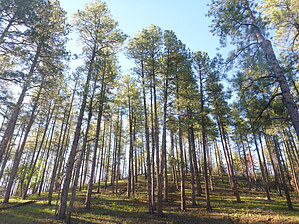
Searching for the Cartwrights on the Ponderosa
by mt98dew

 
Overview
This hike originates from the White Spar trailhead. It is 1 of 4 trails that take off immediately from the spot, with another five trails that are readily accessible. There’s enough parking for about 15 vehicles. Be aware that there’s no water or bathrooms at this trailhead so plan accordingly.


Hike
Take off from the southwest corner of the parking lot, bypassing a road-closed gate. The Ponderosa Trail is basically a road, and as soon as you pass through the gate, the road will split in two directions. The Ponderosa Trail is the one that heads off in the southwest direction (right). As you follow the trail to the east there are forested slopes that climb quickly above you and to the west is Highway 89. And even if you can’t see the road the sound of passing vehicles will be a constant companion for the beginning of the hike. The trail will quickly enter into the trees and is surprisingly well-shaded for a road-like trail. The trail gains a little elevation as it climbs a couple of small hills.
remove free decal offer
At about 0.3 miles a dual track will take off to the east, but other than that the route is never in question. I noted 4 trail markers along the way. At about 0.8 miles the trail will turn away from the road, and begin to climb a couple of staggered hills. At 1 mile you’ll reach the top of one hill and then descend into a valley, giving the hiker their first sense of isolation. The sound of the road will fade into the distance as tree-covered slopes dominate your views. This decline does not last long. Very quickly the trail begins to climb a steep slope for the next 0.3 miles. This ascent also marks a change in the quality of the trail. Up until this point, the trail/road is fairly smooth and drivable by most high-clearance vehicles. But as the trail climbs from the valley it becomes much more rutted and rugged, more suited for quad-like vehicles. Around the 1.4 miles the trail levels off to a much gentler incline. Still gaining elevation but slowly. At 1.6 miles the trail ends when it intersects FR 64. By this point, you have gained enough elevation to get a decent view to the north and west, but the trees and hills will hinder long-distance views in the other directions.

At this time, options are limited. Unlike most of the other trails in the area, the Ponderosa Trail stands alone. One can return the way they came for a 3.2 in and out. Or, one can follow the FR east and use any number of ATV tracks to connect back into the trails that play off of the White Spar TH. Note, none of these tracks are marked and many of these routes can be steep.

Camping
The White Spar TH is also adjacent to a campsite. The area has about 50 campsites that can be utilized by tents as well as RVs. However, there are no RV sanitary dump stations available at the campground. There are 4 bathrooms on site but running water is described as “seasonal.” The cost ranges from 10-28 dollars a night, depending on the season and the site.

Gate Policy: If a gate is closed upon arrival, leave it closed after you go through. If it is open, leave it open. Leaving a closed gate open may put cattle in danger. Closing an open gate may cut them off from water. Please be respectful, leave gates as found. The exception is signage on the gate directing you otherwise.

2023-11-01 mt98dew


    Check out the Official Route and Triplogs.
    Leave No Trace and +Add a Triplog after your hike to support this local community.

    One-Way Notice
    This hike is listed as One-Way.

    When hiking several trails on a single "hike", log it with a generic name that describes the hike. Then link the trails traveled, check out the example.
    WARNING! Hiking and outdoor related sports can be dangerous. Be responsible and prepare for the trip. Study the area you are entering and plan accordingly. Dress for the current and unexpected weather changes. Take plenty of water. Never go alone. Make an itinerary with your plan(s), route(s), destination(s) and expected return time. Give your itinerary to trusted family and/or friends.

     Permit $$
    None

    Prescott Forest
    Prescott National Forest Pass

    Only trailheads with six "amenities" have fees. Amenities are picnic tables, trash, toilet, parking, interpretive signing and security.


     Directions
    or
     Road
    Paved - Car Okay

    To hike
    From the intersection of Gurley and Montezuma Streets in Prescott drive 2.8 miles south on Montezuma (89) which becomes White Spar Road. Just past the Prescott National Forest sign turn left on White Spar Campground Road (there is a sign for White Spar Campground). Cross Granite Creek which parallels the road and park in the unpaved parking lot on the right.
    page created by joebartels on Nov 01 2023 2:52 pm
     90+° 8am - 6pm kills
    helpcorrectionissue

    end of page marker