 Route Editor

| Guide | ♦ | 68 Triplogs | 0 Topics |
details | drive | no permit | forecast | 🔥 route |
stats |
photos | triplogs | topics | location |
| 819 | 68 | 0 |
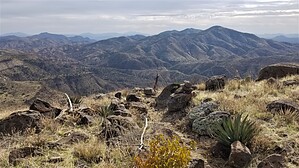
Not as bad a trail as it once was by ShatteredArm  Overview OverviewWord has it that somebody was complaining about the lack of a full guide for Skull Mesa Trail #248, and having managed to cover the length of the trail a few times at this point, it seemed like a good idea to finally write one. Skull Mesa is a tall, flat mesa to the northeast of the Spur Cross Conservation Area, and can be seen from the parking lot. Atop the mesa, at just over 4,500 feet in elevation, one experiences transitional vegetation, with grass, prickly pear cacti, and some juniper. There are also old Native American ruins located on and around the mesa. This guide assumes a west-to-east direction, although it can be hiked however you prefer.
The west end of Skull Mesa Trail is along Cottonwood Trail #247, about 2.5 miles from Cave Creek Trail #4, and almost due north of Cottonwood Spring. There is a gate immediately before the signed junction. The first leg of the trail is a steep, rocky one-mile climb up a ridge, arriving at the top just east of the SW corner of the mesa. From here, there is a short 0.1-mile spur to a point on the end of the mesa offering fantastic views of the surrounding area, including Cottonwood Creek, the Spur Cross Ranch area, Elephant Mountain, and Sugarloaf Mountain. This is where most people turn around, and doing this as an out and back from Spur Cross is a perfectly adequate activity. However, if you choose, you can explore the top of the mesa, or hike the rest of the trail. The caveat is that the stretch of trail across the top of the mesa is only loosely defined: no visible tread; only cairns that are sometimes hard to spot through the vegetation. The official route generally travels in an arc, starting off in a northeasterly direction, but curving east and southeast as you get closer to the other side. If you lose the track (which is quite likely), just make your way towards the southeast corner of the mesa, being careful to avoid the countless prickly pears hiding in the grass. As of this writing, there is a helpful (and impressively tall) cairn marking the location where the descent begins. The route finding on the descent to the Quien Sabe Trail #250 junction is not as difficult; in past years it was covered in grass but has recently been cleared. The next mile (from the Quien Sabe junction to the start of the descent into Cottonwood Creek) used to be nearly impossible to find. This trail has been cleared as of January 2023, so strike while the iron is hot! This section features a short 200-foot climb before dropping down to a saddle lined by chalk-colored rocks and a large juniper. If the trail goes back to nature, your objective is to locate this saddle. The final stretch of the Skull Mesa Trail is a steep one-mile descent to where it rejoins Cottonwood Creek Trail #247. Route finding has never been a problem on this stretch, although in the past, you had to watch out for cacti encroaching on the trail. Water Sources There are no water sources along Skull Mesa Trail, although water can sometimes be found nearby at Cottonwood Spring or where Quien Sabe Trail crosses Mattys Fork. Loop Options While Skull Mesa is commonly hiked as an out-and-back to the SW corner of the mesa, loop options include a Skull Mesa/Cottonwood Lasso, a Quien Sabe/Skull Mesa/Cottonwood loop from Seven Springs, and various off-trail routes for the more adventurous among us. Gate Policy: If a gate is closed upon arrival, leave it closed after you go through. If it is open, leave it open. Leaving a closed gate open may put cattle in danger. Closing an open gate may cut them off from water. Please be respectful, leave gates as found. The exception is signage on the gate directing you otherwise.
Check out the Official Route and Triplogs. Leave No Trace and +Add a Triplog after your hike to support this local community. One-Way Notice This hike is listed as One-Way. When hiking several trails on a single "hike", log it with a generic name that describes the hike. Then link the trails traveled, check out the example. | |||||||||||||||||||||||||||||||||||||||||||||||||||||||||||||||||||||||||||||||||||||||||||||||||||||||||||||||||||||||||||||||||||||||||||||||||||||||||||||||||||||||||||||||||||||||||||||||||||||||


