Travelers can enjoy the transition from desert to forest. Washed out and overgrown in large stretches.
This trail skirts the southern slopes of Four Peaks and then follows Alder Creek to where it climbs to Black Bear Saddle and intersects Four Peaks Trail 130.
When hiking several trails on a single "hike", log it with a generic name that describes the hike. Then link the trails traveled, check out the example.
WARNING! Hiking and outdoor related sports can be dangerous. Be responsible and prepare for the trip. Study the area you are entering and plan accordingly. Dress for the current and unexpected weather changes. Take plenty of water. Never go alone. Make an itinerary with your plan(s), route(s), destination(s) and expected return time. Give your itinerary to trusted family and/or friends.
Permit $$
no fees or permits reported
if incorrect tell us about it
Directions
Road
Strictly 4x4
To Cane Trailhead From Scottsdale follow Shea Blvd East to its terminus at SR87. Turn Left onto SR87. Follow SR87(this is the Beeline) to the Four Peaks Turnoff which is FR143. FR143 is well marked. Follow FR143 to FR 401. Hang a right onto FR401(FR401A in 2023) and follow past Cottonwood Camp. Continue to where FR401 ascends out of Cottonwood Creek up the side of the mountain. Here on it's strictly 4x4. It starts low-key for the first couple of miles then turns... fun! It's 6 miles to Cane Spring Trailhead. The 4x4 section alone takes 1 to 1.5 hours.
Keep in mind albeit near the valley this is about 5 hours round trip depending on variables.
From PHX (I-10 & AZ-51) 52.0 mi, 1 hour 37 mins From TUC (Jct 1-10 & Grant) 150 mi, 3 hours 7 mins From FLG (Jct I-17 & I-40) 179 mi, 3 hours 38 mins In current traffic: 3 hours 38 mins I-17 S
 Route Editor

 Travelers can enjoy the transition from desert to forest. Washed out and overgrown in large stretches.
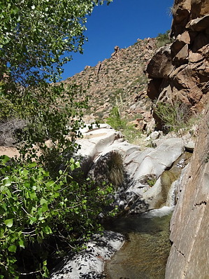


