 Route Editor

| Guide | ♦ | 4 Triplogs | 0 Topics |
details | drive | no permit | forecast | 🔥 route |
stats |
photos | triplogs | topics | location |
| 77 | 4 | 0 |
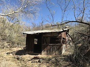
One-Way Trip to Fig Cabin by jacobemerick  Overview OverviewShort and barely-used trail above the Verde River that leads to an old cabin along Sheep Creek. It is difficult to access and offers few loop options, although the final destination is well worth the venture. History Fig Spring Cabin was built by Joe Martin in the 1940s and is still in great shape. He also planted the first fig tree near the Fig Spring.
Reaching the trailhead is, as with many of the western Mazatzal trails, the first challenge. It is located along FR477 on the east side of the Verde River, which is only a road in the most liberal of definitions. The quickest way to get to the trailhead is by crossing the Verde River at the end of FR2109 (by FR42), although one could do a dry crossing at Horseshoe Dam and cross-country from KA Ranch south. Either way, look for a twisted stump next to the road near the coordinates to start the trail. From the start just head east, following a wide tread leftover from an old track, crossing one small wash along the way before dropping into a larger cut at 0.7 miles. This second cut has an unnamed spring HAZ calls Fig Trail Spring at the bottom that may be trickling water. Tracking a way up the opposite bank may be difficult, as it appears that the old trail was washed out, so just pick a route up and worry about finding the tread on top. The trail continues east/southeast, crossing a few small washes along the way. Cairns are few and far between, though the tread is defined enough to follow. At 1.9 miles the trail sticks to the south bank of a wash for some time, only breaking away to follow a small tributary to the right, and then hauls uphill to crest on a barren moonscape of a ridge. Follow the obvious path left (it is tempting to go right) and keep to the tread. At 2.7 miles there is a fork. The best route is to the left, which continues to follow the hills up and around several deep gullies and will loop back down to a grassy saddle at 3.4 miles. An alternate route would be to go right and follow one of the ridges down, and then deal with one or two steep crossings. From the grassy saddle Sheep Creek finally comes into view. Trotting down the red sandy wash is easy, which flows right into the main creek. Follow the creek downstream (which is pretty overgrown) for a few hundred yards. Both Fig Spring and the cabin will be on the south bank, in that order. Once at the cabin, one could either backtrack to FR477 or continue down Sheep Creek to the Verde River, or maybe embark on some more adventurous off-trail option. Water Sources The unnamed spring 0.7 miles into the trail may be flowing. Otherwise, both Fig Spring and Sheep Creek are reliable at the end of the trail. Camping The cabin area looks like it'd make a great campsite - please treat it with respect. It's (probably) older than you. Check out the Official Route and Triplogs. Leave No Trace and +Add a Triplog after your hike to support this local community. One-Way Notice This hike is listed as One-Way. When hiking several trails on a single "hike", log it with a generic name that describes the hike. Then link the trails traveled, check out the example. | ||||||||||||||||||||||||||||||||||||||||||||||||||||||||||||||||||||||||||||||||||||||||||||||||||||||


