 Route Editor

| Guide | ♦ | 1 Triplog | 0 Topics |
details | drive | no permit | forecast | 🔥 route |
stats |
photos | triplog | topics | location |
| 30 | 1 | 0 |
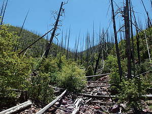
Manzanita and Deadfall by jacobemerick   Overview OverviewThis trail provides an alternate route from Brody Seep junction to Bear Spring, swinging low into the tributaries of South Fork Deadman Creek instead of climbing up along the Mazatzal Divide Trail (AZT). Mileage is about the same, though the view is less grand due to the lower elevation. Warning Heavy, heavy damage from the Willow Fire of '04. The first two miles are choked with manzanita and other nasty brush; then the rest is manzanita, nasty brush, and deadfall. Few cairns and faint tread make for a challenging route-finding exercise. Do not expect to go faster than a mile/hour on this 'trail'.
Starting from Brody Seep trail, head southwest a short distance until the route drops into a rocky wash. Tread is easy to follow, if overgrown, but I couldn't pick it up along the banks. Follow the wash downstream to 0.3 miles and then hack a way up the south bank before the drop. There is a faint tread to be found here, though the deadfall is so thick it's best to find your own way up. Above the manzanita, things will get rocky and grassy. Pick a way down the base of the cliffs to continue south. I couldn't find the trail here with the long grass and no cairns and did my best to avoid the rock slides. Beyond the cliffs, things open up a bit to provide respite before dropping into and crossing a shallow drainage at 1.0 miles. Thick brush makes this a fun crossing. On the other side, the trail twists to the east and rides along the base of a tall, steep hill. Tread is visible here, though plenty of game trails compete for attention. The path drops into a wash at 1.3 miles near some giant sycamores. Take this downstream to 1.6 miles and then turn south and hack through some terribly thick brush, the worst stuff yet, to the next wash over. Or you could continue down and turn left and follow the fork upstream. That's the more innovative way to do it. Now it's time for the first climb. Follow the ridge up, staying mostly on the top, where hints of tread can provide too-short breaks from the onslaught of manzanita. Trail seemed to zig-zag sharply up the ridge and was not the easiest to follow. Near 2.3 miles, start veering to the east, where you get to deal with more of the same, only taller and now with dead pine trees to hop over. Aim for the closest saddle. Once on top there is a great view to the south and the next, 1000'+, climb. Heading down is not that tough, not with hints of trail and relatively lighter brush on this side. Finding the tributary that leads up towards Bear Spring is annoying. It doesn't seem to make a recognizable dent in the bank. Find a spot and clamber up and enjoy the view up the rocky, choked climb ahead. It's not as bad as it looks if you balance from one trunk to the next, connecting them in a zig-zag route up the wash, only using the prickly berry bush-covered banks when necessary. There is some decent flowing rock pools along this stretch too, the last ones by the fork under a two-tiered and mossy waterfall. Above the waterfall, things get drier, and the creek gets skinnier. More rock-hopping is required here, and the logs make for a less conducive route. Some lusher greenery and grass show up near the sight of Fisher Spring and Tank, though I wasn't able to find any pools or moist dirt near the waypoint. From here, the plotted route zips up the northern bank. On top, there are a few cairns and hints of tread, and the brush isn't quite as thick as one would think. 0.2 miles on this ridge and the relative highway of Mazatzal Divide Trail shows up to provide some relief. Water Sources Tributary below Fisher Tank and Spring seems to have some decent rock pools. A few of the washes along the trail had stagnant pools that probably should not be depending on. Check out the Official Route and Triplog. Note This is a moderately difficult hike. Leave No Trace and +Add a Triplog after your hike to support this local community. One-Way Notice This hike is listed as One-Way. When hiking several trails on a single "hike", log it with a generic name that describes the hike. Then link the trails traveled, check out the example. | ||||||||||||||||||||||||||||||||||||||||||||||||||||||||||||||||||||||||||||||||||||||||||||||||||||||


