 Route Editor

| Guide | ♦ | 35 Triplogs | 0 Topics |
details | drive | no permit | forecast | 🔥 route |
stats |
photos | triplogs | topics | location |
| 534 | 35 | 0 |
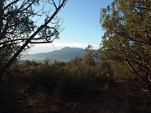
Big Steps to Hardscrabble Mesa by jacobemerick   Overview OverviewSaddle Ridge Trail climbs up from the bank of East Verde River to Hardscrabble Mesa, ascending from one mesa to the next, steadily climbing through a fantastic mix of grasslands and forests. The entire length is part of the Arizona Trail and is relatively well-defined and easy to follow for a Mazatzal Trail. It is most often traveled by AZT hikers, as connecting loops would involve venturing into more remote areas. Hike Reaching the southern end of this trail is a two-part process. Getting to Doll Baby Trailhead can be a muddy slog, depending on the condition of FR 406. Then, the road is gated at Doll Baby, and getting to the start of Saddle Ridge Trail means a 3.6-mile walk down a rocky two-track (aka FR 406W). However, if you're doing a longer trek along the AZT, the chances are that this road walk will not be necessary, and you'll start as it connects with either Bull Spring Trail or FR 194.
Once across the river there is a slight climb to Polk Spring at 1.1 miles, a few hundred feet gain under big, shady trees. Polk Spring is a lovely spot to pull fresh water before a big climb ahead. Speaking of, the first big step shows up shortly after the spring, a 600' haul up a painfully rocky road with little shade or respite. At 1.9 miles, the crest of Polles Mesa arrives, and the tread flattens out. Polles Mesa is a wide, flat mesa, with sporadic trees, lots of rocks, and green grass. The tread may be difficult to follow across the mesa, though the trail mostly cuts a straight line across it, only bending on the far side of Red Saddle Tank. Along this walk there are some good views back south at North Peak. At 3.9 miles, there is a sharp turn eastward at the edge of the next mesa, and at 4.3 miles Whiterock Spring shows up, the last appealing source of water along the trail. The trail quickly cuts back to the West from the spring and makes a steep 200' climb over white rocks to Whiterock Mesa. At the crest of this mesa is a fantastic campsite at 4.5 miles with ridiculous views back south. The proximity to the spring below, the shade, and good views make this one of the best sites along the AZT. Continuing north, the trail makes a slow and steady gain along the mesa, picking up a few hundred feet over several miles, winding through a mixture of pine forests and open grasslands. There is a small dip into a drainage near the end of this section. The third and final step shows up at 7.4 miles, a 500' haul up to Saddle Ridge. It is not as steep as the previous two and gradually rounds out at the end, though it also offers good views south to North Peak, as much of this trail's climbs tend to do. Saddle Ridge is quite rocky, and the tread may be difficult to follow. Keep an eye out for the cairns. Also, elevation continues to sneak in while on the ridge, piling on an additional few hundred feet every mile. At 10.1 miles, the singletrack gives way to an old two-track, and the rest of the hike is simply following that until FR 194. From here, one can turn right to continue on the AZT or hop in a vehicle. Water Sources Polk and Whiterock Spring are the two most appealing sources along this trail. Other sources include East Verde River at Rock Creek, Red Saddle Tank, and Saddle Ridge Tank. Camping The site above Whiterock Spring is simply excellent. Polles Mesa and Polk Spring could also make for less established sites in a pinch. Gate Policy: If a gate is closed upon arrival, leave it closed after you go through. If it is open, leave it open. Leaving a closed gate open may put cattle in danger. Closing an open gate may cut them off from water. Please be respectful, leave gates as found. The exception is signage on the gate directing you otherwise. Check out the Official Route and Triplogs. Leave No Trace and +Add a Triplog after your hike to support this local community. One-Way Notice This hike is listed as One-Way. When hiking several trails on a single "hike", log it with a generic name that describes the hike. Then link the trails traveled, check out the example. | ||||||||||||||||||||||||||||||||||||||||||||||||||||||||||||||||||||||||||||||||||||||||||||||||||||||||||||||||||||||||||||||||||||||||||||||||||||||||||||||||||||||||||||||||||||||||||||||||||||||||||||||||||


