 Route Editor

| Guide | ♦ | 13 Triplogs | 0 Topics |
details | drive | no permit | forecast | 🔥 route |
stats |
photos | triplogs | topics | location |
| 63 | 13 | 0 |
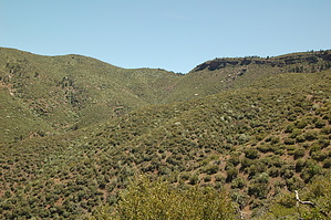
Short Connector on AZT by jacobemerick   Overview OverviewThis is a short connector between two longer trails of the Mazatzals, Bull Spring and Red Hills, and its full length is well-maintained and part of the Arizona Trail. Its relatively short length makes it easy to blink and miss for thru-hikers. Starting halfway up the climb from East Verde River towards the heights of Knob Mountain, Brush Trail offers some excellent views of the northern end wilderness and beyond. Hike The northern end starts when Bull Spring decides to leave the AZT, veering off to the west towards a certain back-country cabin of some renown, leaving most hikers to continue south. There's a bit of a drop as Brush Trail swings in and out of a few drainages. After this there is a decent climb, a gradual 600' haul up sandy switchbacks towards the saddle at 1.1 miles. Depending on the time of day this section, while steep, may be shaded.
At 3.2 miles the trail leaves the drainage and makes a steep climb over a rocky, rolling tread. Once on top of this ridge, things change to a flatter, almost mesa-like geography. Also, the vegetation begins to change up here, shifting from the endless fields of manzanita to a more mixed variety of stubby trees and manzanita. After another gentle climb the San Francisco Peaks may be visible on a clear day. A short while later and the junction with Red Hills Trail takes over the AZT, letting Brush Trail end with its connection task complete. Water Sources Brush Spring is about halfway along the trail and may have water. Camping There are a few clearings near Brush Spring that make for great campsites. Check out the Official Route and Triplogs. Leave No Trace and +Add a Triplog after your hike to support this local community. One-Way Notice This hike is listed as One-Way. When hiking several trails on a single "hike", log it with a generic name that describes the hike. Then link the trails traveled, check out the example. | ||||||||||||||||||||||||||||||||||||||||||||||||||||||||||||||||||||||||||||||||||||||||||||||||||||||||||||||||||||||||||||||||||||||||||||||||||||||||||||||||||||||||||||||||||||||||||||||||||||


