username
X
password
register
for free!
help
 This is likely a great time to hike this trail!  Check out "Preferred" months below, keep in mind this is an estimate.
  🔥

Myrtle Trail #30, AZ

Guide 16 Triplogs  0 Topics
  2.9 of 5  
Fav
Wish
1
details
drive
no permit
forecast
🔥
route  
stats
photos
triplogs
topics
location
0 16 0
Statistics
tap row or icons for details
Difficulty 3 of 5
Distance One Way 1.24 miles
Trailhead Elevation 6,755 feet
Elevation Gain 1,125 feet
Accumulated Gain 1,125 feet
Kokopelli Seeds 4.99
feature photo
Photos Viewed All MineFollowing
Will recalculate on button tap!
5  2024-08-11
Myrtle Point Direct
pseudalpine
14  2024-05-23
Myrtle - Babe Loop
joebartels
20  2024-05-23
Myrtle - Babe Loop
The_Eagle
15  2024-05-23
Myrtle - Babe Loop
wallyfrack
4  2023-06-23
Myrtle Point Loop
pseudalpine
15  2020-09-30
Myrtle Point 7920
DixieFlyer
5  2020-05-23
Myrtle Point Loop
hikerdw
19  2018-05-05
Highline - Myrtle - Devin Loop
The_Eagle
Page 1,  2
Author
author avatar Guides 16,843
Routes 17,472
Photos 24
Trips 1 map ( 6 miles )
Age 28 Male Gender
Location HAZ, TrailDEX
Associated Areas
list map done
Payson Region
Historical Weather
Trailhead Forecast
Radar Map
Expand Map
Preferred Sep, Jun, Aug, Jul
Sun  6:00am - 6:47pm
Official Route & 2 Rts
 
11 Alternative
 
Historic Fire Perimetersacres
🔥 2017 Highline Fire89.4k
🔥 1990 Dude Fire21.4k
🔥 View (All) - over Official Route 🔥


remove free decal offer
Ascend the Mogollon Rim
by HAZ_Hikebot

 Likely In-Season!
Myrtle Trail #30 travels through the "Dude Fire" burn. This area is the scene of the most devastating wildfire in Arizona history. This area is ideal for the study of rejuvenating power.
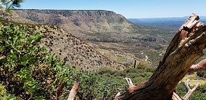

The trail climbs through juniper, Gamble Oak, and pine. Because of the Dude Fire and heavy precipitation, this trail is washed out in many locations. Parking is limited at the north trail terminus on Forest Road (FR) 300. There are a few clearings across the road. Be sure to park well off the road because logging trucks may be using this road.

2018-07-14 HAZ_Hikebot


    Check out the Official Route and Triplogs.
    Leave No Trace and +Add a Triplog after your hike to support this local community.

    One-Way Notice
    This hike is listed as One-Way.

    When hiking several trails on a single "hike", log it with a generic name that describes the hike. Then link the trails traveled, check out the example.
    WARNING! Hiking and outdoor related sports can be dangerous. Be responsible and prepare for the trip. Study the area you are entering and plan accordingly. Dress for the current and unexpected weather changes. Take plenty of water. Never go alone. Make an itinerary with your plan(s), route(s), destination(s) and expected return time. Give your itinerary to trusted family and/or friends.

     Permit $$
    no fees or permits reported

    if incorrect tell us about it


     Directions
    or
     Road


    To hike
    page created by joebartels on Nov 25 2012 2:03 pm
     90+° 8am - 6pm kills
    helpcorrectionissue

    end of page marker