Route Editor

| Guide | ♦ | 1 Triplog | 0 Topics |
details | drive | no permit | forecast | route |
stats |
photos | triplog | topics | location |
| 36 | 1 | 0 |
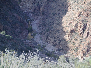
8 ball corner Pocket by topohiker   The Pocket trail starts near the Soldier Camp / Soldier Camp creek. There’s a #38 trail sign off of FR134 (close to the Soldier camp/Soldier camp creek) The first ~1.6 miles is an old Jeep road that fades in and out. At the Wilderness boundary, the road turns into an old ATV trail, then it fades out completely. The Pocket trail starts near the Soldier Camp / Soldier Camp creek. There’s a #38 trail sign off of FR134 (close to the Soldier camp/Soldier camp creek) The first ~1.6 miles is an old Jeep road that fades in and out. At the Wilderness boundary, the road turns into an old ATV trail, then it fades out completely.It appears that the ranchers use this area for cattle grazing. There are cattle paths here and there. You’ll see the Pocket spring and the pocket tank. The trail crosses an unnamed drainage and then it climbs to the east(right). Along the way, red ribbons are hanging from branches. About a third mile from the end you’ll see a black 4inch conduit PVC pipe lashed to a rock. The trail drops down a bit through some rocks and you take the plunge! You drop about 800 feet from this spot. You pick your own path (or poison) down. The terrain is loose scree rocks/dirt with shrubs. Don’t go past this point if you don’t like scrambling or sliding! It’s an energy-draining drop, but the views are worth it. The Tonto creek looks like a mini Grand Canyon in this section of the Hellsgate Wilderness. There’s a lot to explore down in this Canyon.
Check out the Official Route and Triplog. Note This is a more difficult hike. It would be unwise to attempt this without prior experience hiking. Leave No Trace and +Add a Triplog after your hike to support this local community. | |||||||||||||||||||||||||||||||||||||||||||||||||||||||||||||||||||||||||||||||||||||||||||||