 Route Editor

| Guide | 0 Triplogs | 0 Topics |
details | drive | no permit | forecast | 🔥 route |
stats |
photos | triplogs | topics | location |
| 21 | 0 | 0 |
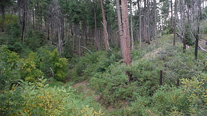
Life Changer (results may vary) by HAZ_Hikebot   From FR 188, Valentine Trail crosses a small arroyo and then gradually climbs a ridge while following the contour on its north side. At a small saddle, the trail turns to the southwest and generally follows the ridge top until it meets with FR 109. Excellent opportunity for all-terrain biking. The trail is surrounded by beautiful Ponderosa pine and fir forest and is located near Valentine Ridge Campground. From FR 188, Valentine Trail crosses a small arroyo and then gradually climbs a ridge while following the contour on its north side. At a small saddle, the trail turns to the southwest and generally follows the ridge top until it meets with FR 109. Excellent opportunity for all-terrain biking. The trail is surrounded by beautiful Ponderosa pine and fir forest and is located near Valentine Ridge Campground.This trail is an old logging road that connects with other roads. Pay attention to trail markers. Visitors can hike or ride directly from Valentine Ridge Campground following FR 188. Travelers can make a loop by returning via FR 109 and FR 188 or make a longer trip continuing on nearby Dan's Trail 550 (to the south of FR 109). FR 188 and FR 109 each have motor vehicle travel, especially on weekends; caution is required when hiking or riding on these roads. The trail is in a previously burned area, it may be hazardous due to downed trees and thick brush and impossible to use at times. Check out the Official Route. Leave No Trace and +Add a Triplog after your hike to support this local community. One-Way Notice This hike is listed as One-Way. When hiking several trails on a single "hike", log it with a generic name that describes the hike. Then link the trails traveled, check out the example. | |||||||||||||||||||||||||||||||||||||||||||||||||||||||||||||||||||||||||||||||||||||||


