Much of the trail follows a pine-covered ridge with spectacular views. The Pinal Mountains are noted for their scenic beauty and ruggedness.
This trail, combined with the Middle Trail 202, provides a connection between most of the trails that head out into the Pinal Mountains. The trail begins at Signal Peak. It crosses Forest Road (FR) 651 at the cattle guard and skirts the Pinal Campground on the west.
When hiking several trails on a single "hike", log it with a generic name that describes the hike. Then link the trails traveled, check out the example.
WARNING! Hiking and outdoor related sports can be dangerous. Be responsible and prepare for the trip. Study the area you are entering and plan accordingly. Dress for the current and unexpected weather changes. Take plenty of water. Never go alone. Make an itinerary with your plan(s), route(s), destination(s) and expected return time. Give your itinerary to trusted family and/or friends.
At the junction of highways 60 & 188 in Claypool, turn right (south) onto Russell Road
Odometer 0.0
- South on Russell Road for 0.35 miles
- DO NOT continue on Golden Hill, Russell turns right
- Continue to 0.65 miles
- DO NOT continue on Rose Mofford Way, Russell turns left
- At 6.3 miles you reach FR 651
Odometer 0.0
- Turn right (south) on FR 651 ( dirt road )
- Continue to 10.2 mi
- Should be room to park just before the cattle guard
page created by joebartels on Nov 26 2012 12:47 am
 Route Editor


 Much of the trail follows a pine-covered ridge with spectacular views. The Pinal Mountains are noted for their scenic beauty and ruggedness.
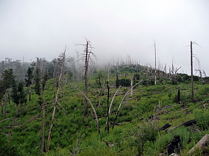


