 Route Editor

| Guide | ♦ | 13 Triplogs | 0 Topics |
details | drive | no permit | forecast | 🔥 route |
stats |
photos | triplogs | topics | location |
| 0 | 13 | 0 |
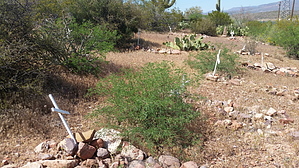
  Roosevelt Cemetery is the final resting place of some local settlers and workers who built the Theodore Roosevelt Dam. A self-guided walk is available. Visitors may pick up brochures at the Tonto Basin Visitor Center located directly across Highway 188. The trail up to the cemetery has a hardened surface and the cemetery interior trails are made of natural material. Roosevelt Cemetery is the final resting place of some local settlers and workers who built the Theodore Roosevelt Dam. A self-guided walk is available. Visitors may pick up brochures at the Tonto Basin Visitor Center located directly across Highway 188. The trail up to the cemetery has a hardened surface and the cemetery interior trails are made of natural material.From the trailhead, the trail gradually climbs a slope on a paved trail to the Roosevelt Cemetery. An interpretative trail winds through the historic cemetery, but it is not suitable for wheelchair users due to its steepness. The trail (unsurfaced) also continues past the cemetery to Thompson Trail 121. Check out the Official Route and Triplogs. Leave No Trace and +Add a Triplog after your hike to support this local community. One-Way Notice This hike is listed as One-Way. When hiking several trails on a single "hike", log it with a generic name that describes the hike. Then link the trails traveled, check out the example. | ||||||||||||||||||||||||||||||||||||||||||||||||||||||||||||||||||||||||||||||||||


