username
X
password
register
for free!
help
  🔥

Alder Saddle Trail #81, AZ

Guide 1 Triplog  0 Topics
  0 of 5  
Fav
Wish
1
details
drive
no permit
forecast
🔥
route  
stats
photos
triplog
topics
location
0 1 0
Statistics
tap row or icons for details
Difficulty 1.5 of 5
Distance One Way 0.59 miles
Trailhead Elevation 5,833 feet
Elevation Gain 518 feet
Accumulated Gain 518 feet
Kokopelli Seeds 2.32
feature photo
Photos Viewed All MineFollowing
13  2012-04-28
Brown's Peak Loop via Alder Saddle
Tough_Boots
Author
author avatar Guides 16,843
Routes 17,472
Photos 24
Trips 1 map ( 6 miles )
Age 28 Male Gender
Location HAZ, TrailDEX
Associated Areas
list map done
Phoenix Region
Historical Weather
Trailhead Forecast
Radar Map
Expand Map
Preferred Mar, Nov, Apr, Feb
Sun  6:01am - 6:47pm
Official Route
 
1 Alternative
 
Historic Fire Perimetersacres
🔥 Three 200550.4 mi*
🔥 2020 Bush Fire193.5k
🔥 2005 Three Fire15.4k
🔥 2005 Edge Complex Fire72.3k
🔥 1996 Lone Fire65.1k
🔥 View (All) - over Official Route 🔥
*perimeter length in miles


remove free decal offer

Guide Needed
Publish Full Detail Guide


Use +Add above to share photos and triplogs
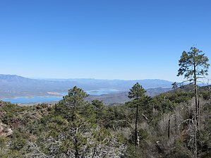
This is an old alignment of Alder Creek Trail, you can see it on the old topo maps. Now it's just to the saddle. Please note that in 2006 the trail vanished well before the saddle due to lack of use and downfall from the fire a decade prior.


    Check out the Official Route and Triplog.
    Leave No Trace and +Add a Triplog after your hike to support this local community.

    One-Way Notice
    This hike is listed as One-Way.

    When hiking several trails on a single "hike", log it with a generic name that describes the hike. Then link the trails traveled, check out the example.
    WARNING! Hiking and outdoor related sports can be dangerous. Be responsible and prepare for the trip. Study the area you are entering and plan accordingly. Dress for the current and unexpected weather changes. Take plenty of water. Never go alone. Make an itinerary with your plan(s), route(s), destination(s) and expected return time. Give your itinerary to trusted family and/or friends.

     Permit $$
    no fees or permits reported

    if incorrect tell us about it


     Directions
    or
     Road


    To hike
    page created by joebartels on Nov 27 2012 10:01 am
     90+° 8am - 6pm kills
    helpcorrectionissue

    end of page marker