 Route Editor

| Guide | ♦ | 1 Triplog | 0 Topics |
details | drive | permit | forecast | route |
stats |
photos | triplog | topics | location |
| 17 | 1 | 0 |
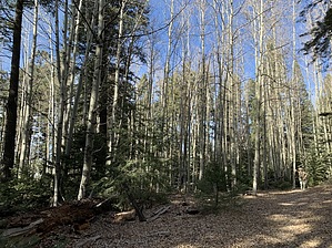
Hike in not Cathey Canyon by markthurman53  The Sacramento Mountains district of the Lincoln National Forest is located in the Southeast section of New Mexico between the Tularosa Basin to the west and the Pecos River Basin to the East. Cloudcroft is the largest town along Highway 82 at the crest of the mountains. Up between 8 and 9000 feet, this is a perfect summer getaway or an excellent area for winter sports. The forests are composed of Douglas Fir, Ponderosa pine, Aspen, and Oak. There is a wide range of wildlife, including Deer, Elk, and Bear. Cloudcroft is a popular recreational site for many kinds of activities, including camping and hiking. There are over 100 miles of hiking trails within 30 miles of Cloudcroft, many of which are along old logging roads, railroad grades, and existing old trails. Views from the ridges of the Sacramento Mountains over the Tularosa Basin are superb, assuming the weather conditions permit. CATHEY CANYON TRAIL #T105A
The Cathey Canyon Trail #T105A follows just below the Sacramento Mountains Rim just north of the Sunspot Observatory. This trail starts and ends on the Rim Trail #T105 and paralleling it just below the rim. The Cathey Canyon Trail, in spite of its name, does not follow along Cathey Canyon. Cathey Canyon is on the east side of the Sacramento Mountain Rim, with its origin at Cathey Vista, located along the Sunspot Highway. The Cathey Canyon Trail is along the western slopes of the Sacramento Mountain Rim and traverses a couple of tributaries of the San Andres Creek. I thought this trail had a sort of mystical feel to it because it meanders along an old-growth forest and is kind of dark because of the dense fir tree forest and occasionally would lighten up a bit as you pass through aspen groves. This is a nice trail and worth the time if you have an hour or two to kill. If you choose to do this in July or August, which is a really nice time to do this hike, be aware that it is monsoon season, and thunderstorms can be quite severe and happen rapidly. Description The trailhead for this trail is the Rim Trail #T105 along the road that leads to the Sunspot Observatory. Heading north from the trailhead, the Cathey Canyon Trail #T105A is .3 miles in on the Rim Trail. The Cathey Canyon Trail will veer off to the west, keeping a fairly constant elevation only climbing 100 feet then dropping back down 100 feet for the first 1.3 miles. This is an actual trail which around here is kind of rare; most are old logging roads or train grades. The trail is in good condition, and deadfall along the trail has been cleared. Someone did a lot of work cutting sections out of the deadfall to clear the path. There is one section where three massive trees fell (3-foot diameter) fairly close together with cutouts in each of the logs, forming a kind of maze that the trail maneuvers through, quite interesting. There are some pretty impressive fir trees along this trail, along with some very large ones that have split and fallen. There are a few sections of aspen trees, especially toward the north end of the trail. There are not a lot of views over the Tularosa Basin because of the tree cover; Better views are along the Rim Trail. The last 0.7 miles, the trail climbs up 200 feet to meet up with the Rim Trail #T105. From this junction, you can either head back the way you came, which is 2.3 miles or head back along the Rim Trail, which is 2 miles. Cathey Vista is 0.8 miles south on the Rim Trail and the sunspot road 1.2 miles from there. Check out the Official Route and Triplog. Leave No Trace and +Add a Triplog after your hike to support this local community. One-Way Notice This hike is listed as One-Way. When hiking several trails on a single "hike", log it with a generic name that describes the hike. Then link the trails traveled, check out the example. | |||||||||||||||||||||||||||||||||||||||||||||||||||||||||||||||||||||||||||||||||||||||||


