Route Editor

| Guide | ♦ | 4 Triplogs | 0 Topics |
details | drive | no permit | forecast | map |
stats |
photos | triplogs | topics | location |
| 19 | 4 | 0 |
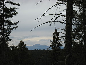
Yes, you can hike this! by Jim Most of this hike is in fairly dense Fir forest, both Douglas and White, with some Aspen throughout, and a little Ponderosa Pine near the lower areas and even some Englemann Spruce near the top. It's shady, cool, and probably moist most of the time. I found light snow patches in mid-April after a dry winter. I also chanced to do this on a very cold, moist and overcast day. In shorts! It was wishful thinking. Anyway, plan for temps 20 to 30 degrees cooler than Alamogordo, and likely rain in monsoon season. This would make a decent snowshoe area in winter after a big storm.
Trail 5006 ascends at a gentle pace for a little over 2 miles. Slightly beyond the half way point, you will come to an intersection with #5005A. Ignore this and keep on the main stem and follow 5006. The next intersection is with 5007C, which may not be obvious but it is slightly open in this area. Keep on 5006 about another 3/4 of a mile and find the upper trailhead. This is marked with a nice sign as well and you can't miss it. This is where 5006 meets 5007, and it hardly seems like a destination. Continue on 5007 to the Benson Ridge Road, AKA FR 223. As you approach 223, notice the higher terrain above the road to the north of the intersection and between the two sections of 223, which forms a "V" in this area as it wraps around you destination. Hike up this hill, cross a very slight saddle and ascend to the recently thinned, but still dense with aspen and white fir highpoint at 9695'. On the "summit", there is a red can with a register in it. It was obvious the day I hiked this. Views are lacking, but you can see Sierra Blanca though the trees, as well as the Organ Mountains in a few locations. This more or less boring hill needs a fire tower, or something. Return the way you hiked up. Check out the Triplogs. Leave No Trace and +Add a Triplog after your hike to support this local community. | ||||||||||||||||||||||||||||||||||||||||||||||||||||||||||||||||||||||||||||||||||||||||||